-
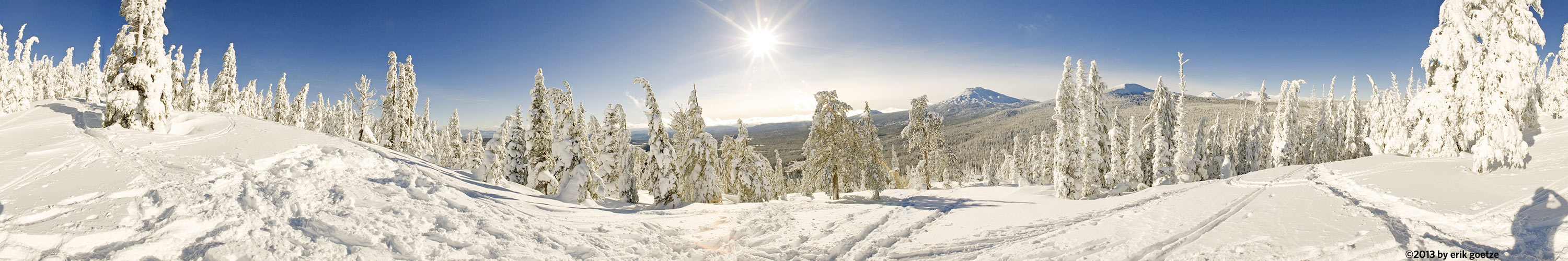 This 360 panorama is from Vista Butte, Oregon
VirtualParks alpha list
Panoramic Scenes starting with the character Panoramas beginning with the letter M
Pick a letter or number: A B C D E F G H I J K L M N O P Q R S T U V W X Y Z Alpha list of parks
| Place | Notes |
|---|---|
| Main Quad, Stanford University Campus | |
| Mainly Tidy Tips, Park 319 | |
| Malakoff Diggins nr 1, Malakoff Diggins State Historic Park | |
| Malakoff Diggins nr 2, Malakoff Diggins State Historic Park | |
| Maligne Lake pier, Jasper National Park | |
| Mandan Summit nr2, Wasatch Range | |
| Manzana Creek Crossing, Los Padres National Forest (Southern) | |
| Manzana Trail nr1, Los Padres National Forest (Southern) | This location is less than a mile from the trailhead |
| Manzana Trail nr2, Los Padres National Forest (Southern) | 200 ft past where I ran into two backpackers who missed the Hurricane Deck turnoff |
| Manzana Trail nr3, Los Padres National Forest (Southern) | Overlooking a campground and beautiful spot along Manzana Creek |
| Marie Lake, Sierra National Forest | Shot with Francois Mercat's 2 oz. panhead |
| Masses of Owl Clover, Park 319 | |
| Masses of Tidy Tips, Park 319 | |
| Matadero Creek Trail, Baylands Nature Preserve | |
| Mather Pass nr 1, Kings Canyon National Park | Shot with Francois Mercat's 2 oz. panhead |
| Mather Pass nr 2, Kings Canyon National Park | Shot with Francois Mercat's 2 oz. panhead |
| Mayfield Slough lock, Baylands Nature Preserve | |
| McClure Beach, Point Reyes National Seashore | |
| McClure Beach near Elephant Rock, Point Reyes National Seashore | |
| McClure Beach south end, near Elephant Rock, Point Reyes National Seashore | |
| McClure Meadow, Kings Canyon National Park | Shot with Francois Mercat's 2 oz. panhead |
| McDonald Gulch, Castle Rock State Park | |
| McGarvey Flat next to gully, Huddart County Park | |
| Meadow along Silver Pass Creek, Sierra National Forest | |
| Meadow along the road to Hetch Hetchy reservoir, Yosemite National Park | YOS13 |
| Meadow near Nature Center, Foothills Park | Only PA Residents allowed! |
| Meadow near Visitor Center, Hidden Villa Preserve | |
| Meadow south of Whitehouse Creek, Ano Nuevo State Park - Cascade Ranch | Incredible picturesque area |
| Meadow to north of Whitehouse Creek, Ano Nuevo State Park - Cascade Ranch | Beautiful view of surrounding forested mountains |
| Meadowlark Trail and Access Road, Arastradero Preserve | |
| Meadowlark Trail near Acorn Trail, Arastradero Preserve | |
| Medicine Lake, Jasper National Park | It looked like rain, but didn't until late at night. |
| Memorial Court, Stanford University Campus | |
| Merced Riverbank mid-valley floor, Yosemite National Park | Forgetting snowshoes, I sank several feet into the snow on the way out |
| Middle Edgewood, Edgewood County Park | Lots of pretty Godetia wildflowers amongst the dry grass visisble here. |
| Middle hilltop across from IBM Research, Stile Ranch | |
| Middle Mist Falls, above round rock cavity, Kings Canyon National Park | |
| Middle of Peters Creek loop, Portola Redwoods State Park | "CUTLOG" ROLL4. The only person I saw this day walked by while I was in the middle of this shoot. He was wearing an Apple cap. |
| Middle of the lake, Loch Lomand Recreation Area | |
| Middle Peters Creek loop nr 2, Portola Redwoods State Park | ROLL4. Some tiger lilies nearby. |
| Midway around lake, Loch Lomand Recreation Area | |
| Midway up the main road, Purisima Creek Redwoods Preserve | |
| Mill on Aptos Creek, The Forest of Nisene Marks State Park | Site of historical Mill |
| Mining spot overlooking Round Lake, Lakes Basin | Mining equipment was still visible here |
| Mist Falls Looking at Sphinx, Kings Canyon National Park | |
| Mitchell Canyon nr1 (rocky slope), Mt. Diablo | |
| Mitchell Canyon nr5, Mt. Diablo | |
| Mitchell Canyon Trail nr2 (linanthus field), Mt. Diablo | |
| Mitchell Canyon Trail nr3 (canyon overlook), Mt. Diablo | |
| Mitchell Canyon Trail nr4, Mt. Diablo | |
| Mitchell Canyon Trail nr5 (3/4 way to Deer Flat), Mt. Diablo | |
| Molera Ridge Overlook, Andrew Molera State Park | Ultra windy, haze obscured Point Sur lighthouse point |
| Molybdynite Creek nr 2, Toiyabe National Forest | MOLYB2 |
| Mono Creek above Fourth Recess, Sierra National Forest | |
| Mono Creek between First and Second Recess, Sierra National Forest | |
| Mono Pass east end, Sierra National Forest | |
| Mono Pass eastern ascent, Sierra National Forest | |
| Mono Pass west end, Sierra National Forest | |
| Mono Tufa Formations nr 1, Mono Lake | |
| Mono Tufa Formations nr 2, Mono Lake | |
| Mono Tufa Formations nr 3, Mono Lake | |
| Mono Tufa Formations nr 4, Mono Lake | |
| Mono Tufa Formations nr 5, Mono Lake | |
| Mono Tufa Formations nr 6, Mono Lake | The last shot of the day. |
| Montara Mountain nr 1, McNee Ranch and Montara State Beach | Spectacular view from San Francisco to Pigeon Point |
| Montara Mountain nr 2, McNee Ranch and Montara State Beach | View of entire Coastside, and up to Mt. Tam |
| Moraine Lake inlet, Banff National Park | |
| Moraine Lake Pier, Banff National Park | It had just started to rain. |
| Moraine Lake rockpile near outlet nr 2, Banff National Park | |
| Moraine Lake viewpoint near outlet nr 1, Banff National Park | |
| Moraine Lake west shore, Banff National Park | It's hard to believe the color of the water is really this green, but it is. |
| Morning alpenglow on Mt. Timp, Wasatch Range | |
| Mossy Log along Bridge Creek Trail, The Forest of Nisene Marks State Park | Interesting forest |
| Mt. Bielawski Fire Road nr 1, Castle Rock State Park | |
| Mt. Bielawski Fire Road nr 2, Castle Rock State Park | |
| Mt. Bielawski Fire Road nr 3, Castle Rock State Park | |
| Mt. Carmel, Ventana Wilderness | The observation pole that used to be intact is now shreds. |
| Mt. McAbee, Big Basin Redwoods State Park | Great view out to Waddell Beach |
| Mt. Tam, Mt. Tamalpais State Park | Wonderful view of the Bay from slightly below top of Mt. Tam |
| Mt. Whitney Summit during wildfire nr 1, Kings Canyon National Park | |
| Mt. Whitney Summit during wildfire nr 2, Kings Canyon National Park | |
| Mt. Whitney Trail Crest nr 1, Inyo National Forest | |
| Mt. Whitney Trail Crest nr 2, Kings Canyon National Park | |
| Muir Pass nr1, Kings Canyon National Park | Shot with Francois Mercat's 2 oz. panhead |
| Muir Pass nr2, Kings Canyon National Park | Shot with Francois Mercat's 2 oz. panhead |
| Muir Woods, Muir Woods | A sunny day at Muir Woods, and quite a few people on the walkway. This was taken at a memorial for the meeting of Allied leaders after WWII. |
| Muir Woods at stream, Muir Woods | My friend Mark is shooting a backlit maple leaf on the bridge. High contrast makes this scene difficult. |
| Mulesear hill N Meadowlark nr2, Arastradero Preserve | |
| Mulesear hill N of Meadowlark nr1, Arastradero Preserve | |
| Mustard grass near Perimeter Trail, Arastradero Preserve |
For a different panorama every day, visit VRlog.com, which works in all popular browsers and supports fullscreen viewing and WebVR.