-
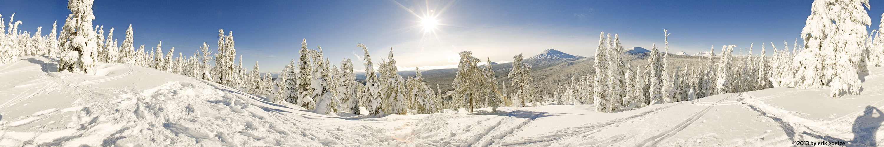 This 360 panorama is from Vista Butte, Oregon
VirtualParks alpha list
Panoramic Scenes starting with the character Panoramas beginning with the letter H
Pick a letter or number: A B C D E F G H I J K L M N O P Q R S T U V W X Y Z Alpha list of parks
| Place | Notes |
|---|---|
| Hamilton and Alma, Downtown Palo Alto | Across from 100 Hamilton(Sun) |
| Hamilton and High Street, Downtown Palo Alto | Lots of curious glances from walks-by--but also the first person to recognize what I was doing |
| Hayfield Rd nr1, Sunol Regional Park | |
| Hayfield Rd nr2, Sunol Regional Park | |
| Hayfield Rd nr3, Sunol Regional Park | |
| Headwaters clearcut nr 1, Headwaters Forest Reserve | |
| Headwaters clearcut nr 2, Headwaters Forest Reserve | |
| Headwaters of Bubbs Creek, Kings Canyon National Park | |
| Heart Lake, Sierra National Forest | Shot with Francois Mercat's 2 oz. panhead |
| Helen Lake overlook, Kings Canyon National Park | Shot with Francois Mercat's 2 oz. panhead |
| Helen Lake shore, Kings Canyon National Park | Shot with Francois Mercat's 2 oz. panhead |
| Henry Coe nr 1, Henry Coe State Park | HCOE1 |
| Henry Coe nr 2, Henry Coe State Park | HCOE2 |
| Henry Coe nr 3, Henry Coe State Park | HCOE3 |
| Henry Coe nr 4, Henry Coe State Park | HCOE4 |
| Henry Coe nr 5, Henry Coe State Park | HCOE5 |
| Henry Coe nr 6, Henry Coe State Park | HCOE6 |
| Henry Coe nr 7, Henry Coe State Park | HCOE7 |
| Henry Coe nr 8, Henry Coe State Park | HCOE8 |
| Hickory Oak Ridge, Ward Road, Long Ridge Preserve | "OAKVIEW" ROLL1. Mariposa lilies growing nicely down the road from here. |
| High Meadow Trail, Rancho San Antonio Preserve | A good view of the canyon, but too hazy to see much of Silicon Valley. The PG&E road/trail is clearly visible across the canyon. |
| High Point of park, Stile Ranch | |
| High Street and Forest, Downtown Palo Alto | In front of Palo Alto Weekly...but no one noticed I was shooting them. |
| High Valley Camp nr1, Sunol Regional Park | |
| High Valley Camp nr2, Sunol Regional Park | |
| Highland Trail overlook, Loch Lomand Recreation Area | |
| Highway 1 and Whitehouse Road, Ano Nuevo State Park - Cascade Ranch | |
| Highway 395 overlooking aspens, Toiyabe National Forest | "395-1". Just short of road to Virginia Lakes. |
| Hiker's Hut, Pescadero Creek County Park | Could see Pacific waves |
| Hill 1096, Big Basin Redwoods State Park | View of Chalk Mountain Lookout |
| Hill 535, Ano Nuevo State Park - Cascade Ranch | |
| Hill 600, Ano Nuevo State Park - Cascade Ranch | Could almost see Pigeon Point lighthouse |
| Hill above trailhead/parking, La Honda Creek Preserve | Some haze reduced visibilty of Pacific |
| Hill along east edge of Preserve, Arastradero Preserve | |
| Hill at SE corner of park, Arastradero Preserve | |
| Hill between Corte Madera and Meadowlark Trail nr 1, Arastradero Preserve | |
| Hill east of parking lot nr 2, Arastradero Preserve | |
| Hill next to Big Dish, Stanford University Campus | Many Ithariel's Spear wildflowers in bloom |
| Hill next to Whitehouse Road, Ano Nuevo State Park - Cascade Ranch | Low clouds stick to the mountaintops--sun was just coming out. |
| Hill overlooking golf course, Arastradero Preserve | |
| Hill overlooking west end of park, Arastradero Preserve | |
| Hill overlooking Whitehouse Creek, Ano Nuevo State Park - Cascade Ranch | Survey flagging caused mis-focus |
| Hillside across from Indian Joe Creek Trail nr 2, Sunol Regional Park | Wonderful array of Owl Clover here |
| Hillside flowers midway along trail, Stile Ranch | |
| Hilltop across from IBM Research, Stile Ranch | |
| Hilltop along trail to former cottage site, Arastradero Preserve | |
| Hilltop near golf course, Arastradero Preserve | |
| Hilltop near Ranger Peak, Los Padres National Forest (Southern) | A wonderful view of the Santa Barbara backcountry |
| Hilltop near Ranger Peak nr2, Los Padres National Forest (Southern) | A slightly different angle on the wonderful view here |
| Hilltop overlooking peninsula nr1, Point Reyes National Seashore | |
| Hilltop overlooking peninsula nr2, Point Reyes National Seashore | |
| Hilltop overlooking peninsula nr3, Point Reyes National Seashore | Could see Tamales Point as well as Point Reyes |
| Hilltop overlooking S. Fork Kings River valley, Kings Canyon National Park | Shot with Francois Mercat's 2 oz. panhead |
| Hilltop south of Borel Hill nr 1, Russian Ridge Open Space | |
| Hilltop south of Borel Hill nr 2, Russian Ridge Open Space | Thousands of Violets were blooming |
| Hilltop south of Borel Hill nr 3, Russian Ridge Open Space | |
| Hilltop south of Borel Hill nr 4, Russian Ridge Open Space | |
| Hilltop view along trail to Chimney Rock, Point Reyes National Seashore | |
| Hinckley Creek crossing, The Forest of Nisene Marks State Park | |
| Historic Barn nr 3, Burleigh Murray State Park | |
| Historic Barn nr3, Burleigh Murray State Park | |
| Hog Canyon nr 2, Glen Canyon National Recreation Area | HOG2 |
| Homer and Emerson , Downtown Palo Alto | Across from Whole Foods |
| Homer and High Street, Downtown Palo Alto | Across from the famous Peninsula Creamery building |
| Homer and Waverly, Downtown Palo Alto | Church landmark |
| Homer Street in front of Peets, Downtown Palo Alto | testing the new KiWi+ rig |
| Hoodoo on trail down to Vista Lake, Banff National Park | This area was scorched in a fire about 15 years previously. |
| Hoover Lake nr 1, Toiyabe National Forest | Another rock field |
| Hoover Lake nr 2, Toiyabe National Forest | Set up in a muddy spot |
| Horse Camp, Sam MacDonald County Park | Spring, deer were grazing |
| Horse Creek nr 1, Toiyabe National Forest | Stream under trees |
| Horse Creek nr 2, Toiyabe National Forest | A beaver dam had killed all these trees |
| Horse Creek nr 3, Toiyabe National Forest | |
| Horse Creek nr 4, Toiyabe National Forest | |
| Horse Creek nr 5, Toiyabe National Forest | Meadow with single tree |
| Horse Creek nr 7, Toiyabe National Forest | A wonderful pond near sunset |
| Horse Creek nr 8, Toiyabe National Forest | |
| Horse field along road to Aspen Grove, Wasatch Range | |
| Horse Pasture along road to Aspen Grove nr2, Wasatch Range | |
| Horsecollar ruins nr 1, Natural Bridges National Monument | |
| Horsecollar ruins nr 2, Natural Bridges National Monument | It's a dangerous, tough slickrock scramble to get up here. |
| Horseshoe Lake, Skyline Ridge Preserve | Muddy after the rains |
| Horseshoe Lake, Jasper National Park | |
| Hotel Creek Overlook, Kings Canyon National Park | |
| Hotel Creek trail, Kings Canyon National Park | This location is about 1/3 mile from the end of Hotel Creek Trail where it intersects Lewis Creek trial |
| Hotel Trail fork with Bass Lake Trail, Joseph D. Grant County Park | |
| Hotel Trail fork with Lower Hotel Trail, Joseph D. Grant County Park | |
| Humphreys Basin nr 1, Sierra National Forest | My first view of Mt. Humphreys of this trip |
| Humphreys Basin nr 2, Sierra National Forest | Shot from near where the trail to Desolation Lake splits off |
| Hutchinson Meadow, Sierra National Forest | At the confluence of Puite Creek and French Canyon streams |
| Hwy 180 overlook, Kings Canyon National Park | Great view from just off the 180 highway. |
| Hwy 180 view of Spanish Mtn, Sequoia National Forest |
For a different panorama every day, visit VRlog.com, which works in all popular browsers and supports fullscreen viewing and WebVR.