-
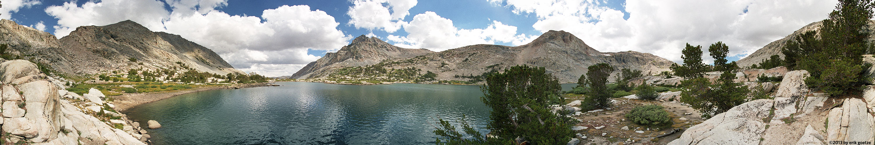 This 360 panorama is from Piute Lake, California
VirtualParks alpha list
Panoramic Scenes starting with the character Panoramas beginning with the letter E
Pick a letter or number: A B C D E F G H I J K L M N O P Q R S T U V W X Y Z Alpha list of parks
| Place | Notes |
|---|---|
| Eagle Lake, Desolation Wilderness | "Tahoe1" |
| Eagle Peak nr 2, Yosemite National Park | |
| Eagle Rock summit, Big Basin Redwoods State Park | |
| Eagle Rock summit nr 2, Big Basin Redwoods State Park | Chaparrel pea bushes were in bloom |
| East Bluffs overlooking Capitola, Capitola | Shot with a home-made panhead |
| East end of Butano Ridge, Pescadero Creek County Park | |
| East end of Lake Thomas A Edison, Sierra National Forest | |
| East end of Meadow south of Whitehouse Creek, Ano Nuevo State Park - Cascade Ranch | This is probably very near the site of the large Ohlone village. |
| East end of Peters Creek loop nr2, Portola Redwoods State Park | To get a sense of the scale, check out the 6 inch banana slug crawling at the base of the tree. |
| East end of Peters Creek loop nr3, Portola Redwoods State Park | Got so excited at the incredible trees I forgot to finish the panorama, so its a partial. |
| East Lake, Toiyabe National Forest | |
| East Ridge Trail, Big Basin Redwoods State Park | The fallen redwood tree shown had over 400 rings visible. |
| Edge of aspen forest, Wasatch Range | |
| Edge of Road, Wasatch Range | This just up from "edge of aspen forest" |
| Edge of the Cedars nr 2, Misc. Utah Locations | Taken from atop the reconstructed kiva |
| Edgewood Oaks, Edgewood County Park | Dramatic view of some oaks on the northwest corner of the reserve. If the camera was two feet higher, you would see the 280 freeway just beyond the lone oak. |
| Edgewood Overlook, Edgewood County Park | |
| El Camino Real, in front of Kepler's , Menlo Park | |
| El Corte de Madera Creek nr 1, El Corte de Madera Preserve | About 0.5 miles down from the trailhead |
| El Corte de Madera Creek nr 2, El Corte de Madera Preserve | Beautiful redwood forest |
| El Corte de Madera sandstone formation, El Corte de Madera Preserve | Sandstone is not well lit here. The one hiking-only trail in ECdM |
| El Corte de Madera viewpoint, El Corte de Madera Preserve | Severe contrast beyond what the film could handle. Nice view looking out to San Gregorio valley. |
| El Palo Alto tree, Downtown Palo Alto | View the historic tree |
| Elk Creek Tributary nr 2, Headwaters Forest Reserve | |
| Emerson and Lytton, Downtown Palo Alto | Shows the new big buildings on Lytton |
| Empty lot wildflowers nr 1, Park 319 | WLDFL1 |
| Enchanted Loop Trail, Wilder Ranch State Park | The forest is enchanted only when no one is shouting. |
| End of Island, Loch Lomand Recreation Area | |
| End of trail, Burleigh Murray State Park | |
| End of Woodcutter trail, Wilder Ranch State Park | |
| Engelsman Loop Redwoods, Wilder Ranch State Park | |
| Englesman Trail overlook point, Wilder Ranch State Park | |
| Entering Tully Hole nr 1, Sierra National Forest | |
| Entering Tully Hole nr 2, Sierra National Forest | |
| Entrance to McClure Beach, Point Reyes National Seashore | |
| Esplanade nr 1, Capitola | |
| Esplanade nr 2, Capitola | Shot with a home-made panhead |
| Evolution Lake, Kings Canyon National Park | Shot with Francois Mercat's 2 oz. panhead. |
| Evolution Valley Meadow, Kings Canyon National Park | Shot with Francois Mercat's 2 oz. panhead |
| Ewing Hill north knob nr1, Hidden Villa Preserve | |
| Ewing Hill north knob nr2, Hidden Villa Preserve | |
| Excavation behind limekiln, Pogonip Park | Wonderful leaf-fall and wet rocks |
For a different panorama every day, visit VRlog.com, which works in all popular browsers and supports fullscreen viewing and WebVR.