-
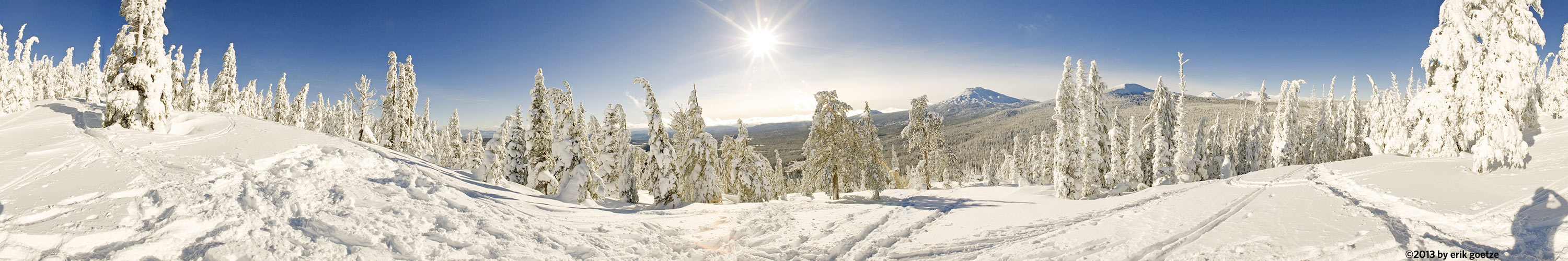 This 360 panorama is from Vista Butte, Oregon
VirtualParks alpha list
Panoramic Scenes starting with the character Panoramas beginning with the letter P
Pick a letter or number: A B C D E F G H I J K L M N O P Q R S T U V W X Y Z Alpha list of parks
| Place | Notes |
|---|---|
| Page Mill site, Portola Redwoods State Park | There is not much left to see of the mill. |
| Page Mill site upstream, Portola Redwoods State Park | Forest makes the sunlight solid |
| Pampas Grass ridge, Ano Nuevo State Park - Cascade Ranch | Good view of hill which might be developed with a house |
| Park HQ and launching point, Loch Lomand Recreation Area | |
| Parking Lot at Park HQ, Big Basin Redwoods State Park | |
| Parking lot H, Downtown Palo Alto | View of Il Fornaio restaurant |
| Parking lot to parking lot trail, Windy Hill Preserve | |
| Parking lot to Parking lot trail nr 2, Windy Hill Preserve | |
| Partington Ridge chaparrel, Los Padres National Forest (Northern) | |
| Partington Ridge overlook, from below logpile, Los Padres National Forest (Northern) | |
| PCT near Crater Lake visitor center nr1, Crater Lake National Park | |
| PCT near Crater Lake visitor center nr2, Crater Lake National Park | |
| PCT Section O approaching Grizzly Peak, Shasta National Forest | |
| Peaseley Gulch crossing, Wilder Ranch State Park | Poor GPS coverage here |
| Peers Park, Downtown Palo Alto | |
| Pescadero Beach dune, Pescadero State Beach | The fogbank was trying to overrun the beach. |
| Pescadero Marsh, Pescadero State Beach | Late in the day, but the sun is still pretty high. |
| Pescadero Marsh overlook and bench , Pescadero State Beach | Pescadero Marsh is not only beautiful to look at, but a vital habitat |
| Peters Creek Loop, middle, Portola Redwoods State Park | Saw only one person that day |
| Peters Creek Loop, north end, Portola Redwoods State Park | First generation old redwoods |
| Peters Creek Loop, south end, Portola Redwoods State Park | 3 cm long termites common here |
| Peters Creek, north of apple orchard, Long Ridge Preserve | Incredible green scene with moss-covered rocks, ferns, trees |
| Peyto Lake viewpoint, Banff National Park | It was hard to get the hordes of tourists out of the picture. |
| Pier at upper Echo Lake, Desolation Wilderness | DES5 |
| Pier on Pond, Skyline Ridge Preserve | |
| Pigeon Point lighthouse, Pigeon Point Light Station State Historic Park | The ocean mist nicely dimmed the sun's strength on the lighthouse |
| Pillar point harbor, at base of hill, Montara | No remote shutter release; didn't adjust for focal point of tamron lens; rig was not quite level |
| Pillar Point nr 2, Coastside Beaches | This completes a loop of 300 panoramas, back at the site of my first. |
| Pinchot Pass, Kings Canyon National Park | Shot with Francois Mercat's 2 oz. panhead |
| Pine Ridge, Ventana Wilderness | Hard to find a viewpoint on this mountain due to fierce after fire growth |
| Pine Valley, Ventana Wilderness | Incredible clouds of bugs in the valley |
| Pinnacles nr 0, Pinnacles National Monument | PIN0 |
| Pinnacles nr 1, Pinnacles National Monument | PIN1 |
| Pinnacles nr 2, Pinnacles National Monument | PIN2 |
| Pinnacles nr 4, Pinnacles National Monument | PIN4 |
| Pinnacles nr 5, Pinnacles National Monument | PIN5 |
| Pinnacles nr 6, Pinnacles National Monument | PIN6 |
| Piute Lake, Sierra National Forest | |
| Piute Pass nr 1, Sierra National Forest | |
| Piute Pass nr 2, Sierra National Forest | From a rock outcrop just east of the high point of the pass |
| Pogonip initial hill near south entrance, Pogonip Park | |
| Point Arena, Northern California Coastline | The lighthouse keeper is very aggressive about keeping people from straying |
| Point below Coast Ridge Road nr1, Los Padres National Forest (Northern) | Just beyond halfway up to the ridgetop |
| Point below Coast Ridge Road nr2, Los Padres National Forest (Northern) | Just beyond halfway up to the ridgetop |
| Point below Coast Ridge Road nr3, Los Padres National Forest (Northern) | Just beyond halfway up to the ridgetop |
| Point Bonita Lighthouse nr 1, Golden Gate National Recreation Area | The "front" of the lighthouse, with interpretive panel. |
| Point Bonita Lighthouse nr 2, Golden Gate National Recreation Area | From the "back" of the lighthouse, facing the great Pacific |
| Point Bonita Lighthouse nr 3, Golden Gate National Recreation Area | From the back, only with a wider angle lens |
| Point Lobos sunset, Point Lobos State Reserve | |
| Point Montara Lighthouse nr 2, Coastside Beaches | On a bluff north of the lighthouse |
| Point Montara Lighthouse nr 3, Coastside Beaches | South of the Lighthouse |
| Point Pinos Lighthouse nr 1, Point Pinos | |
| Point Reyes, Point Reyes National Seashore | Ocean and bluff view from atop some rocks at the gate to the lighthouse |
| Point Reyes bluffs, Point Reyes National Seashore | Sunset's fading light on the bluffs north of Point Reyes. |
| Point Reyes nr 2, Point Reyes National Seashore | Closer to sunset |
| Point Sur Barracks Visitor Center, Big Sur | A superb view looking back on the "mainland" |
| Point Sur Lighthouse Blacksmith Shop, Big Sur | This was shot down below the new water tank |
| Point Sur Lighthouse Keeper's Dwellings, Big Sur | |
| Point Sur Lighthouse nr 2, Big Sur | The lighthouse uses similar rock facing as old buildings at Stanford. |
| Point Tomales Trail nr2, Point Reyes National Seashore | |
| Point Tomales Trail nr3, Point Reyes National Seashore | |
| Pomponio Beach Bluff, Pomponio State Beach | Excellent viewpoint of some fine coastside beaches |
| Pomponio Trail near Camp Pomponio, Pescadero Creek County Park | |
| Pond, Long Ridge Preserve | Waterfowl present but not visible |
| Pond along Wilder Ridge Trail, Wilder Ranch State Park | Redwood trees here are all topped. Lupines in foreground. |
| Pond near Bass Lake nr2, Joseph D. Grant County Park | |
| Poppies Acorn Trail and Access nr1, Arastradero Preserve | |
| Poppies Acorn Trail and Access nr3, Arastradero Preserve | |
| Poppies along first switchbacks, Stile Ranch | |
| Poppies and tidy tips, Park 319 | |
| Poppies aside hill next to Access Road and Meadowlark Trail, Arastradero Preserve | |
| Poppies off Ridge Trail, Russian Ridge Open Space | |
| Poppies on hill between Acorn Trail and Access Road nr4, Arastradero Preserve | |
| Poppies on hill between Acorn Trail and Access Road nr5, Arastradero Preserve | |
| Poppies on Partington Ridge nr1, Los Padres National Forest (Northern) | Perhaps the best poppy field with a view I've seen |
| Poppies on Partington Ridge nr2, Los Padres National Forest (Northern) | The broom plant, while pretty, is non-native |
| Poppy field at entrance, Wilder Ranch State Park | This field could be seen from miles away on Hwy 1 |
| Poppyfield aside hill nr2, Arastradero Preserve | |
| Poppyfield aside hill nr3, Arastradero Preserve | |
| Poppyfield nr4, Arastradero Preserve | |
| Poppyfield nr5, Arastradero Preserve | |
| Portola Trail along Fall Creek, Portola Redwoods State Park | The afternoon light falling on a waterfall |
| Pt. Reyes Lighthouse, Point Reyes National Seashore | Pt. Reyes is reputed to be the second foggiest place in the US. |
| Punta Gorda Lighthouse, King Range National Conservation Area | The BLM tore down supporting structures in 1970. |
| Purisima Creekbottom nr 1, Purisima Creek Redwoods Preserve | |
| Purisima Creekbottom nr 2, Purisima Creek Redwoods Preserve | |
| Purisima Creekbottom nr 3, Purisima Creek Redwoods Preserve | Beautiful maidenhair ferns here |
| Purisima Creekside nr 1, Purisima Creek Redwoods Preserve | |
| Purisima Hog Gulch Creekbottom, Purisima Creek Redwoods Preserve | There is a crude but satisfying bench by the leaning tree. |
| Purple Lake, Sierra National Forest |
For a different panorama every day, visit VRlog.com, which works in all popular browsers and supports fullscreen viewing and WebVR.