-
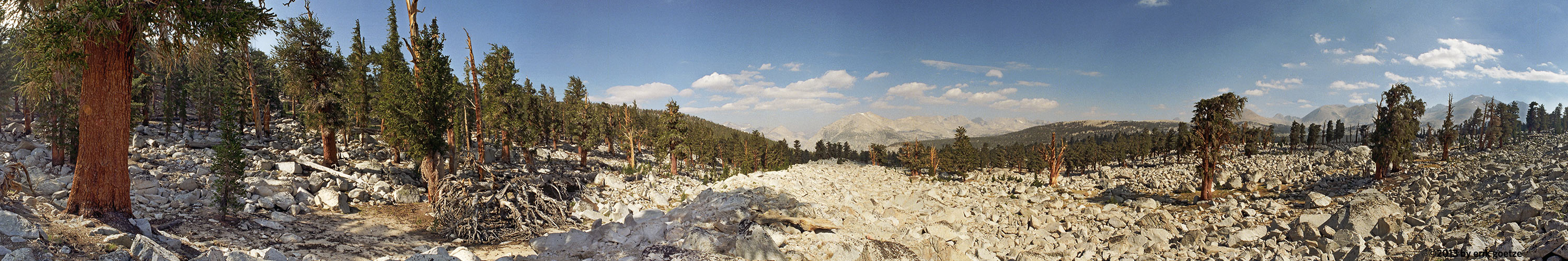 This 360 panorama is from PCT north of Mt. Whitney
VirtualParks ranked list
Quality ranked list of top 500 panoramas
| Place | Quality Rank | Date |
|---|---|---|
| Lake Smedburg, along the PCT, Yosemite National Park | 1 | Shot with Francois Mercat's 2 oz. panhead |
| Ridge north of Forester Pass nr 2, Kings Canyon National Park | 2 | Shot with Francois Mercat's 2 oz. panhead |
| Moraine Lake west shore, Banff National Park | 3 | It's hard to believe the color of the water is really this green, but it is. |
| Los Trancos Trail nr 2, Foothills Park | 4 | |
| Dorothy Lake nr 2, along PCT, Yosemite National Park | 5 | Shot with Francois Mercat's 2 oz. panhead |
| Lake Ediza, Ansel Adams Wilderness | 6 | MAM4 |
| Moraine Lake rockpile near outlet nr 2, Banff National Park | 7 | |
| Horsecollar ruins nr 2, Natural Bridges National Monument | 8 | It's a dangerous, tough slickrock scramble to get up here. |
| Lake Louise opposite Boathouse, Banff National Park | 9 | |
| Tenaya Creek above Mirror Lake, Yosemite National Park | 10 | Very marshy here; got my feet wet hopping from island to island |
| Lower Lamarck Lake nr 2, Inyo National Forest | 11 | |
| Forester Pass, Kings Canyon National Park | 12 | |
| Peyto Lake viewpoint, Banff National Park | 13 | It was hard to get the hordes of tourists out of the picture. |
| Brown Creek Trail nr 3, Prairie Creek Redwoods State Park | 14 | |
| Moraine Lake inlet, Banff National Park | 15 | |
| Upper Lamarck Lake, Inyo National Forest | 16 | |
| JMT between Guitar Lake and Trail Crest nr 2, Kings Canyon National Park | 17 | |
| JMT between Guitar Lake and Trail Crest, Kings Canyon National Park | 18 | |
| Yosemite northern border PCT trail, Yosemite National Park | 19 | Shot with Francois Mercat's 2 oz. panhead |
| Brown Creek Trail nr 5, Prairie Creek Redwoods State Park | 20 | |
| Evolution Lake, Kings Canyon National Park | 21 | Shot with Francois Mercat's 2 oz. panhead. |
| Moraine Lake viewpoint near outlet nr 1, Banff National Park | 22 | |
| Mono Tufa Formations nr 6, Mono Lake | 23 | The last shot of the day. |
| Timberline Lake, Kings Canyon National Park | 24 | |
| Between two lakes at head of Tyndall Creek, Kings Canyon National Park | 25 | |
| Kearsarge Pass, Kings Canyon National Park | 26 | |
| Green Creek nr 3, Toiyabe National Forest | 27 | |
| Buckeye Tree along road to Big Dish, Stanford University Campus | 28 | Wonderful craggy tree and view |
| Second Lake nr 2, Inyo National Forest | 29 | |
| Rock shelf below Center Peak on JMT, Kings Canyon National Park | 30 | Taken from off the trail, on a rock bench near the headwaters of Bubbs Creek |
| Elk Creek Tributary nr 2, Headwaters Forest Reserve | 31 | |
| Trail to Lamarck Col nr 2, Inyo National Forest | 32 | |
| Piute Lake, Sierra National Forest | 33 | |
| Mt. Whitney Summit during wildfire nr 1, Kings Canyon National Park | 34 | |
| Mather Pass nr 2, Kings Canyon National Park | 35 | Shot with Francois Mercat's 2 oz. panhead |
| Glen Pass nr 2, Kings Canyon National Park | 36 | Shot with Francois Mercat's 2 oz. panhead |
| Overlooking Piute Crags, Sierra National Forest | 37 | |
| Mt. Whitney Summit during wildfire nr 2, Kings Canyon National Park | 38 | |
| Sandy Meadow, Kings Canyon National Park | 39 | |
| Top of switchbacks overlooking Vidette Meadow, Kings Canyon National Park | 40 | Shot with Francois Mercat's 2 oz. panhead |
| Glen Pass nr 1, Kings Canyon National Park | 41 | Shot with Francois Mercat's 2 oz. panhead |
| Mt. Whitney Trail Crest nr 2, Kings Canyon National Park | 42 | |
| View of Nevada Falls from trail, Yosemite National Park | 43 | YOS12 |
| Mono Tufa Formations nr 5, Mono Lake | 44 | |
| East Lake, Toiyabe National Forest | 45 | |
| Bodie nr 6, Toiyabe National Forest | 46 | A miner's cabin which has been preserved as it was. |
| Bensen Pass, Yosemite National Park | 47 | Shot with Francois Mercat's 2 oz. panhead |
| Lamarck Col, Kings Canyon National Park | 48 | |
| Yosemite Falls trail nr 2, Yosemite National Park | 49 | YOS3 |
| Seavey Pass area along PCT Trail, Yosemite National Park | 50 | Shot with Francois Mercat's 2 oz. panhead |
| Piute Pass nr 1, Sierra National Forest | 51 | |
| Pinchot Pass, Kings Canyon National Park | 52 | Shot with Francois Mercat's 2 oz. panhead |
| Ridge north of Forester Pass nr 1, Kings Canyon National Park | 53 | This is the last point with a grand view down Bubbs Creek Canyon |
| Wilcox Pass nr 4, Jasper National Park | 54 | Bighorn sheep were grazing right and left. |
| Mather Pass nr 1, Kings Canyon National Park | 55 | Shot with Francois Mercat's 2 oz. panhead |
| North Wash painting of the Moki Queen, Glen Canyon National Recreation Area | 56 | also known as 'Cleopatra'. A Barrier Canyon style painting. |
| Rockefeller Loop nr 3, Humboldt Redwoods State Park | 57 | |
| Irvine Trail nr 3, Prairie Creek Redwoods State Park | 58 | |
| Headwaters of Bubbs Creek, Kings Canyon National Park | 59 | |
| Darwin Bench overlooking Evolution Lakes Basin, Kings Canyon National Park | 60 | |
| Purisima Creekbottom nr 1, Purisima Creek Redwoods Preserve | 61 | |
| Rock field south of Wallace Creek, Kings Canyon National Park | 62 | |
| Western Rim Trail nr 1, Crater Lake National Park | 63 | This was shot handheld |
| Guitar Lake shore, Kings Canyon National Park | 64 | |
| Lower Rae Lake, Kings Canyon National Park | 65 | Shot with Francois Mercat's 2 oz. panhead |
| Atop Nevada Falls, Yosemite National Park | 66 | YOS8 |
| Purisima Creekbottom nr 3, Purisima Creek Redwoods Preserve | 67 | Beautiful maidenhair ferns here |
| Mono Tufa Formations nr 3, Mono Lake | 68 | |
| Piute Pass nr 2, Sierra National Forest | 69 | From a rock outcrop just east of the high point of the pass |
| Green Lake nr 1, Toiyabe National Forest | 70 | |
| Descent from Evolution Valley nr 2, Kings Canyon National Park | 71 | |
| Bull Creek tributary, Humboldt Redwoods State Park | 72 | |
| Merced Riverbank mid-valley floor, Yosemite National Park | 73 | Forgetting snowshoes, I sank several feet into the snow on the way out |
| Third Darwin Lake, Kings Canyon National Park | 74 | |
| Brown Creek Trail nr 4, Prairie Creek Redwoods State Park | 75 | |
| Sipapu Bridge nr 1, Natural Bridges National Monument | 76 | Shot from a ledge on the trail down |
| Fern Canyon along stream, Prairie Creek Redwoods State Park | 77 | |
| Seldon Pass, Sierra National Forest | 78 | Shot with Francois Mercat's 2 oz. panhead |
| Moraine Lake Pier, Banff National Park | 79 | It had just started to rain. |
| Aptos Creek Trail nr 1, The Forest of Nisene Marks State Park | 80 | A small slide down the mountain caused this open space. |
| Rock overlooking unnamed lake and Rae Lake, Kings Canyon National Park | 81 | Shot with Francois Mercat's 2 oz. panhead |
| Looking down on Palisade Creek canyon, Kings Canyon National Park | 82 | Shot with Francois Mercat's 2 oz. panhead |
| Dewey Pt. nr 2, Yosemite National Park | 83 | |
| Eagle Peak nr 2, Yosemite National Park | 84 | |
| Bull Creek nr 3, Humboldt Redwoods State Park | 85 | |
| Rocky outcrop between Helen Lake and Le Conte Canyon, Kings Canyon National Park | 86 | Shot with Francois Mercat's 2 oz. panhead |
| Lake Marjorie on the John Muir Trail, Kings Canyon National Park | 87 | Shot with Francois Mercat's 2 oz. panhead |
| Upper Rae Lake, Kings Canyon National Park | 88 | Shot with Francois Mercat's 2 oz. panhead |
| Wilcox Pass nr3, Jasper National Park | 89 | Some bighorn sheep were lounging in the distance. |
| Below Whitney Summit, snowfield, Inyo National Forest | 90 | |
| Mt. Whitney Trail Crest nr 1, Inyo National Forest | 91 | |
| Lake Ediza outlet, Ansel Adams Wilderness | 92 | |
| Yosemite Falls trail nr 3 (atop the falls), Yosemite National Park | 93 | YOS5 |
| Above Eagle Lake, Desolation Wilderness | 94 | |
| Horse Creek nr 4, Toiyabe National Forest | 95 | |
| Trail Junction on Hotel Creek Trail, Kings Canyon National Park | 96 | I met one hiker on this trail, right here |
| Fallen log over Bear Creek, Portola Redwoods State Park | 97 | Had to get off the log and use the infrared remote to fire the camera from some angles. |
| Wanda Lake nr2, Kings Canyon National Park | 98 | Shot with Francois Mercat's 2 oz. panhead |
| Second Darwin Lake nr 2, Kings Canyon National Park | 99 | Shot with Francois Mercat's 2 oz. panhead |
| Sapphire Lake, Kings Canyon National Park | 100 | Shot with Francois Mercat's 2 oz. panhead |
| Long Lake, Inyo National Forest | 101 | LNGLK1 |
| Canyon View Trail nr 5, Sunol Regional Park | 102 | |
| Bull Creek nr 1, Humboldt Redwoods State Park | 103 | |
| Bullfrog Lake, Kings Canyon National Park | 104 | Unbelievably bad smoke from a giant fire 75 miles away |
| Dewey Pt. nr 1, Yosemite National Park | 105 | |
| Lake Tahoe shoreline, Tahoe National Forest | 106 | |
| Next to Archery Fire Road in fog, Huddart County Park | 107 | Shot with a home-made panhead |
| Grouse Meadow nr 2, Kings Canyon National Park | 108 | Shot with Francois Mercat's 2 oz. panhead |
| Surfing Museum nr 3, Santa Cruz | 109 | |
| Santa Cruz surfer statue 'To Honor Surfing' nr 2, Santa Cruz | 110 | |
| Old bridge site across Palisade Creek, Kings Canyon National Park | 111 | Shot with Francois Mercat's 2 oz. panhead |
| Surfing Museum nr 2, Santa Cruz | 112 | |
| Chesler Park Trail nr 7, Canyonlands National Park | 113 | CANYN6 |
| Virginia Lake nr 3, Toiyabe National Forest | 114 | The aspen tree bark is bathed in yellow glow, reflecting from the carpet of golden aspen leaves. |
| Mono Tufa Formations nr 4, Mono Lake | 115 | |
| Purisima Creekbottom nr 2, Purisima Creek Redwoods Preserve | 116 | |
| Pomponio Beach Bluff, Pomponio State Beach | 117 | Excellent viewpoint of some fine coastside beaches |
| Waterfall at top of Le Conte Canyon, Kings Canyon National Park | 118 | Shot with Francois Mercat's 2 oz. panhead |
| Helen Lake overlook, Kings Canyon National Park | 119 | Shot with Francois Mercat's 2 oz. panhead |
| Irvine Trail nr 2, Prairie Creek Redwoods State Park | 120 | Shot with a home-made panhead |
| Bridge over Piute Creek, Kings Canyon National Park | 121 | Shot with Francois Mercat's 2 oz. panhead |
| Aptos Creek Trail nr 4, The Forest of Nisene Marks State Park | 122 | You can see the raindrops hitting the water. |
| Gray Whale Ranch nr 5, Wilder Ranch State Park | 123 | |
| East Bluffs overlooking Capitola, Capitola | 124 | Shot with a home-made panhead |
| Rock ledge overlooking Charlotte Lake, Kings Canyon National Park | 125 | Shot with Francois Mercat's 2 oz. panhead |
| Muir Pass nr2, Kings Canyon National Park | 126 | Shot with Francois Mercat's 2 oz. panhead |
| Aptos Creek above Big Slide nr 7, The Forest of Nisene Marks State Park | 127 | |
| Sipapu Bridge nr 2, Natural Bridges National Monument | 128 | MOB |
| JMT between Sapphire Lk. and Wanda Lake, Kings Canyon National Park | 129 | Shot with Francois Mercat's 2 oz. panhead |
| West Bluffs overlooking Capitola, Capitola | 130 | |
| Irvine Trail nr 1, Prairie Creek Redwoods State Park | 131 | |
| Small unnamed Lake west of Twin Lakes, Kings Canyon National Park | 132 | Shot with Francois Mercat's 2 oz. panhead |
| Overlooking Sallie Keyes Lakes, Sierra National Forest | 133 | Shot with Francois Mercat's 2 oz. panhead |
| Heart Lake, Sierra National Forest | 134 | Shot with Francois Mercat's 2 oz. panhead |
| Western Rim Trail nr 3, Crater Lake National Park | 135 | The figures in the distance were some Nordic club members. |
| Muir Pass nr1, Kings Canyon National Park | 136 | Shot with Francois Mercat's 2 oz. panhead |
| North side of Mather Pass, Kings Canyon National Park | 137 | Shot with Francois Mercat's 2 oz. panhead |
| Stream along road to BYU camp, Wasatch Range | 138 | |
| Wilcox Pass nr5, Jasper National Park | 139 | Seemed like the highpoint of the pass: you could see far in both direcitons. |
| Lake Louise Boathouse nr2, Banff National Park | 140 | |
| Aptos Creek above Big Slide nr 5, The Forest of Nisene Marks State Park | 141 | |
| Aptos Creek Trail nr 3, The Forest of Nisene Marks State Park | 142 | There is a statue under the bridge I never noticed before. |
| Bishop Pass nr 5, Inyo National Forest | 143 | My thousandth Panorama! Plus or minus one. |
| Shadow Lake, Ansel Adams Wilderness | 144 | Shot with a home-made panhead |
| Buckeye valley nr 3, Toiyabe National Forest | 145 | BCKE2 |
| Virginia Lake nr 2, Toiyabe National Forest | 146 | Everywhere you look inside this aspen forest, it was as if all was aflame. |
| Lembert Dome nr 1, Yosemite National Park | 147 | |
| McGarvey Flat next to gully, Huddart County Park | 148 | |
| Humphreys Basin nr 1, Sierra National Forest | 149 | My first view of Mt. Humphreys of this trip |
| Canyon View Trail nr 10, Sunol Regional Park | 150 | Shot with a home-made panhead |
| Grouse Meadow nr 1, Kings Canyon National Park | 151 | Shot with Francois Mercat's 2 oz. panhead |
| Aptos Creek above Big Slide nr 6, The Forest of Nisene Marks State Park | 152 | |
| Capitola Beach, Capitola | 153 | |
| Junction Meadow, Kings Canyon National Park | 154 | Shot with Francois Mercat's 2 oz. panhead |
| Wilcox Pass nr2, Jasper National Park | 155 | At a turn in the trail, but before any sign of wildlife. |
| Arrow Lake, Kings Canyon National Park | 156 | Shot with Francois Mercat's 2 oz. panhead |
| Rockfield south of Le Conte Ranger Station, Kings Canyon National Park | 157 | Shot with Francois Mercat's 2 oz. panhead |
| Whitney Summit nr 3, Sequoia National Park | 158 | |
| Triple viewshed off Coast Ridge Road, Los Padres National Forest (Northern) | 159 | |
| Southern Overlook, La Honda Creek Preserve | 160 | Nice view looking down on Highway 84 and Skylonda. |
| Bluffs overlooking beach south of Pigeon Point, Pigeon Point Light Station State Historic Park | 161 | Shot with a home-made panhead |
| Lembert Dome nr 3, Yosemite National Park | 162 | |
| Along Palisade Creek nr 1, Kings Canyon National Park | 163 | Shot with Francois Mercat's 2 oz. panhead |
| Wilmer Lake, along the PCT, Yosemite National Park | 164 | Shot with Francois Mercat's 2 oz. panhead |
| Trail to Lamarck Col nr 1, Inyo National Forest | 165 | |
| Esplanade nr 2, Capitola | 166 | Shot with a home-made panhead |
| Rockfield near Little Pothole Lake and Gilbert Lake, Inyo National Forest | 167 | Coming out of Onion Valley |
| Lake under Fin Dome, Kings Canyon National Park | 168 | Shot with Francois Mercat's 2 oz. panhead |
| View of Macomb Ridge from the PCT, Yosemite National Park | 169 | Shot with Francois Mercat's 2 oz. panhead |
| Triple Arch, Arches National Park | 170 | Shot with a home-made panhead |
| East end of Lake Thomas A Edison, Sierra National Forest | 171 | |
| Helen Lake shore, Kings Canyon National Park | 172 | Shot with Francois Mercat's 2 oz. panhead |
| Along Palisade Creek nr 2, Kings Canyon National Park | 173 | Shot with Francois Mercat's 2 oz. panhead |
| View of The Citadel in Le Conte Canyon, Kings Canyon National Park | 174 | Shot with Francois Mercat's 2 oz. panhead |
| Third lake before Lake Marjorie (to N.), Kings Canyon National Park | 175 | Shot with Francois Mercat's 2 oz. panhead |
| Lake Louise Boathouse nr1, Banff National Park | 176 | |
| Pt. Reyes Lighthouse, Point Reyes National Seashore | 177 | Pt. Reyes is reputed to be the second foggiest place in the US. |
| Lone Pine Lake, Inyo National Forest | 178 | |
| Whitney summit nr 2, Inyo National Forest | 179 | Second pano -- taken from the northwest corner, near toilet. |
| Whitney Summit nr 1, Sequoia National Park | 180 | First shot on the summit! Taken from the north east corner. |
| Whitehouse Creek streambottom nr 6, Ano Nuevo State Park - Cascade Ranch | 181 | |
| Horse Creek nr 5, Toiyabe National Forest | 182 | Meadow with single tree |
| Sphinx Trail Granite Staircase, Kings Canyon National Park | 183 | SPX4. "Stairway to Heaven." Unbelievable granite stairs. |
| Rocky Creek Bridge, Big Sur | 184 | First regular pano using KiWi panhead |
| Lambert Creek nr 1, Skyline Ridge Preserve | 185 | Taken below the petering out of the road, in the middle of Lambert Creek. |
| Lake on Bailey Ridge, along the PCT, Yosemite National Park | 186 | Shot with Francois Mercat's 2 oz. panhead |
| Roads End permit station, Kings Canyon National Park | 187 | Shot with Francois Mercat's 2 oz. panhead |
| Hilltop overlooking S. Fork Kings River valley, Kings Canyon National Park | 188 | Shot with Francois Mercat's 2 oz. panhead |
| JMT-Just below Mono Creek Trail cutoff, Sierra National Forest | 189 | |
| Point Sur Lighthouse nr 2, Big Sur | 190 | The lighthouse uses similar rock facing as old buildings at Stanford. |
| Loch Leven, Sierra National Forest | 191 | |
| Chesler Park Trail nr 9, Canyonlands National Park | 192 | |
| Crag overlooking junction of Woods and Baxter Creeks , Kings Canyon National Park | 193 | Shot with Francois Mercat's 2 oz. panhead |
| Point Montara Lighthouse nr 3, Coastside Beaches | 194 | South of the Lighthouse |
| Trail out of Onion Valley, Inyo National Forest | 195 | |
| Capitola Pier, Capitola | 196 | Shot with a home-made panhead |
| Beneath Lamarck Col, Inyo National Forest | 197 | |
| First Palisade Lake, Kings Canyon National Park | 198 | Shot with Francois Mercat's 2 oz. panhead |
| Humphreys Basin nr 2, Sierra National Forest | 199 | Shot from near where the trail to Desolation Lake splits off |
| Lower Piute Canyon, Sierra National Forest | 200 | It started raining at noon and didn't let up until 4PM. |
| Between Aspen Meadow and Franklin Meadow, Kings Canyon National Park | 201 | Shot with Francois Mercat's 2 oz. panhead |
| Esplanade nr 1, Capitola | 202 | |
| Rocky hillock east of Guitar Lake, Kings Canyon National Park | 203 | |
| Gilbert Lake, Inyo National Forest | 204 | |
| Big rocks in stream, Huddart County Park | 205 | |
| Hutchinson Meadow, Sierra National Forest | 206 | At the confluence of Puite Creek and French Canyon streams |
| Long House nr 1, Mesa Verde National Park | 207 | Taken from above a number of kivas |
| Descent to San Juaquin River, Kings Canyon National Park | 208 | Shot with Francois Mercat's 2 oz. panhead |
| upper Bubbs Creek view of The Sphinx, Kings Canyon National Park | 209 | Shot with Francois Mercat's 2 oz. panhead |
| JMT overlooking Evolution Lake, Kings Canyon National Park | 210 | Shot with Francois Mercat's 2 oz. panhead. |
| Wanda Lake nr1 (NE end), Kings Canyon National Park | 211 | Shot with Francois Mercat's 2 oz. panhead |
| Salmon Lake island nr2, Lakes Basin | 212 | This was a different small island off the shore of the bigger island nr 1 |
| Salmon Lake island nr1, Lakes Basin | 213 | I had to wade out to the island, getting wet up to my waist. |
| Wilcox Pass nr1, Jasper National Park | 214 | First good view of the glacier |
| Point Bonita Lighthouse nr 1, Golden Gate National Recreation Area | 215 | The "front" of the lighthouse, with interpretive panel. |
| Point Montara Lighthouse nr 2, Coastside Beaches | 216 | On a bluff north of the lighthouse |
| Acorn Trail near Gate C, Arastradero Preserve | 217 | |
| Aspen forest above Silver Lake nr 2, Inyo National Forest | 218 | JUNE5 |
| Delicate Arch nr 1, Arches National Park | 219 | The famous landmark arch |
| Chesler Park Trail nr 8, Canyonlands National Park | 220 | Shot with a home-made panhead |
| Chesler Park Trail nr 6, Canyonlands National Park | 221 | CANYN5 |
| Newspaper Rock nr 1, Misc. Utah Locations | 222 | NEWSRK |
| Lake Powell Observation Point, Glen Canyon National Recreation Area | 223 | LKPWL1 |
| Upper end of Winnemucca Lake, Eldorado National Forest | 224 | CRPAS5 |
| Pier at upper Echo Lake, Desolation Wilderness | 225 | DES5 |
| Rockefeller Loop nr 1, Humboldt Redwoods State Park | 226 | One of the most beautiful redwood forests in the world |
| Mono Tufa Formations nr 1, Mono Lake | 227 | |
| Lembert Dome nr 2, Yosemite National Park | 228 | |
| Horse Creek nr 2, Toiyabe National Forest | 229 | A beaver dam had killed all these trees |
| Mono Tufa Formations nr 2, Mono Lake | 230 | |
| Bubbs Creek, Kings Canyon National Park | 231 | SPX8. Very slippery rocks here. I got my feet wet the first try crossing stream. |
| Sphinx Trail nr 7, Kings Canyon National Park | 232 | SPX7. A nice view past these tall trees. |
| Sphinx Trail, end of hellish ascent, Kings Canyon National Park | 233 | SPX6. Turnaround point for the day. A shoelace broke. |
| Clearing along Paradise Valley Trail, Kings Canyon National Park | 234 | Great view of both sides of Kings Canyon |
| Chair and Table at South Edge of park, Andrew Molera State Park | 235 | This comfy spot just above where the Ridge Trail turns onto the Panorama Trail. |
| East end of Peters Creek loop nr3, Portola Redwoods State Park | 236 | Got so excited at the incredible trees I forgot to finish the panorama, so its a partial. |
| Whitehouse Creek streambottom nr 1, Ano Nuevo State Park - Cascade Ranch | 237 | A small redwood forest exists here along the stream |
| Goat Rock, Castle Rock State Park | 238 | I climbed up the easy way to get this dramatic vista. Butano Ridge is clearly visible behind the rock crest. |
| Small hill overlooking two canyons, Kings Canyon National Park | 239 | Shot with Francois Mercat's 2 oz. panhead |
| Aspen Meadow, Kings Canyon National Park | 240 | Shot with Francois Mercat's 2 oz. panhead |
| Dollar Lake, Kings Canyon National Park | 241 | Shot with Francois Mercat's 2 oz. panhead |
| Above Pine Ridge Trail, Ventana Wilderness | 242 | Great view out beyond Monterey Bay to north, Church Creek rock formations |
| Pescadero Marsh overlook and bench , Pescadero State Beach | 243 | Pescadero Marsh is not only beautiful to look at, but a vital habitat |
| Descent from Evolution Valley nr 1, Kings Canyon National Park | 244 | |
| Grace Meadow, along PCT, Yosemite National Park | 245 | Shot with Francois Mercat's 2 oz. panhead |
| Upper Piute Canyon, Sierra National Forest | 246 | Shot from near the treeline, on a rock slab with great views of the glacier |
| Golden Gate of the Sierra-bridge over Woods Creek, Kings Canyon National Park | 247 | Shot with Francois Mercat's 2 oz. panhead |
| John Muir Trail overlooking Bear Creek valley, Sierra National Forest | 248 | Shot with Francois Mercat's 2 oz. panhead |
| Above Pt. Reyes Lighthouse nr 2, Point Reyes National Seashore | 249 | Taken from the same spot as nr2, but higher up |
| Aptos Creek Trail nr 2, The Forest of Nisene Marks State Park | 250 | It was raining all day here. |
| Aspen grove above Grant Lake nr 2, Inyo National Forest | 251 | There was no trail here. |
| Buckeye valley nr 5, Toiyabe National Forest | 252 | BCKE5 |
| Sphinx Creek Trail, view with trees, Kings Canyon National Park | 253 | SPX5. The view kept getting better. |
| Cedar Grove Overlook, Kings Canyon National Park | 254 | Incredible view down on Cedar Grove and the rest of Kings Canyon |
| Overlooking Woods Creek, Kings Canyon National Park | 255 | Shot with Francois Mercat's 2 oz. panhead |
| Green Creek nr 1, Toiyabe National Forest | 256 | Near trailhead. |
| Bear Gulch Trail nr 3, Wunderlich County Park | 257 | |
| Kehoe Beach bluff nr 5, Point Reyes National Seashore | 258 | |
| Lewis Creek trail, intersection with Hotel Creek Trail, Kings Canyon National Park | 259 | |
| John Muir Trail descending into Bear Creek valley, Sierra National Forest | 260 | Shot with Francois Mercat's 2 oz. panhead |
| Marie Lake, Sierra National Forest | 261 | Shot with Francois Mercat's 2 oz. panhead |
| Takakkaw Falls, Yoho Valley, Yoho National Park | 262 | |
| Aptos Creek ladybug swarm, The Forest of Nisene Marks State Park | 263 | |
| Meadowlark Trail near Acorn Trail, Arastradero Preserve | 264 | |
| Santa Cruz small craft harbor nr 1, Santa Cruz | 265 | SCZBC9 |
| Pinnacles nr 6, Pinnacles National Monument | 266 | PIN6 |
| Purisima Hog Gulch Creekbottom, Purisima Creek Redwoods Preserve | 267 | There is a crude but satisfying bench by the leaning tree. |
| Wilder Creek and nameless gulch, Wilder Ranch State Park | 268 | A mysterious stone structure lay at my feet |
| Pigeon Point lighthouse, Pigeon Point Light Station State Historic Park | 269 | The ocean mist nicely dimmed the sun's strength on the lighthouse |
| Black Forest trail, Wasatch Range | 270 | |
| Tioga Pass Road, snowbound nr 1, Yosemite National Park | 271 | TIAGAS |
| Buckeye valley nr 4, Toiyabe National Forest | 272 | BCKE3 |
| Lundy Lake 1, Inyo National Forest | 273 | |
| Six Bridges Trail, Butano State Park | 274 | Picturesque leaning trees |
| Point Sur Lighthouse Blacksmith Shop, Big Sur | 275 | This was shot down below the new water tank |
| Eagle Rock summit, Big Basin Redwoods State Park | 276 | |
| Stanford Point nr 1, Yosemite National Park | 277 | YOS15 |
| Trees along trail to Velma Lake, Desolation Wilderness | 278 | |
| Zumwalt Meadow nr 3, Kings Canyon National Park | 279 | Best meadow I've seen in the whole valley |
| Rockefeller Loop nr 4, Humboldt Redwoods State Park | 280 | |
| Kehoe Beach bluff nr 4, Point Reyes National Seashore | 281 | |
| West end of Peters Creek grove nr2, Portola Redwoods State Park | 282 | ROLL3. It took forever to complete, as I waited for the sun to be blocked by the occasional fast moving cloud. |
| Evolution Valley Meadow, Kings Canyon National Park | 283 | Shot with Francois Mercat's 2 oz. panhead |
| Aptos Crk above Big Slide nr 2, The Forest of Nisene Marks State Park | 284 | |
| Under Oaks at south end of Corte Madera Trail, Arastradero Preserve | 285 | |
| Eagle Rock summit nr 2, Big Basin Redwoods State Park | 286 | Chaparrel pea bushes were in bloom |
| Along Tioga Pass road, Yosemite National Park | 287 | |
| Molybdynite Creek nr 2, Toiyabe National Forest | 288 | MOLYB2 |
| Buckeye valley nr 2, Toiyabe National Forest | 289 | BCKE1 |
| Kings Canyon Floor, clearing, Kings Canyon National Park | 290 | First serious use of monopod |
| Below Mist Falls, Kings Canyon National Park | 291 | I thought this was Mist Falls. Later it turned out to just be the last of Mist. |
| Park HQ and launching point, Loch Lomand Recreation Area | 292 | |
| Fall Creek, Fall Creek Unit Henry Cowell State Park | 293 | Incredible spot |
| Hoover Lake nr 1, Toiyabe National Forest | 294 | Another rock field |
| Kehoe Beach bluff nr 3, Point Reyes National Seashore | 295 | |
| Yoho River, Yoho National Park | 296 | "Glacial flour" makes the water white. |
| Above Pt. Reyes Lighthouse nr 1, Point Reyes National Seashore | 297 | The foghorn was blaring the whole afternoon |
| Edge of the Cedars nr 2, Misc. Utah Locations | 298 | Taken from atop the reconstructed kiva |
| At Velma Lake, Desolation Wilderness | 299 | |
| Bubbs Creek Trail, Kings Canyon National Park | 300 | SPX1. This trail is as steep as the rangers at the trailhead promised. |
| Hwy 180 overlook, Kings Canyon National Park | 301 | Great view from just off the 180 highway. |
| Bull Creek nr 5, Humboldt Redwoods State Park | 302 | |
| Henry Coe nr 7, Henry Coe State Park | 303 | HCOE7 |
| Eagle Lake, Desolation Wilderness | 304 | "Tahoe1" |
| Rosemarie Meadow, Sierra National Forest | 305 | Shot with Francois Mercat's 2 oz. panhead |
| Medicine Lake, Jasper National Park | 306 | It looked like rain, but didn't until late at night. |
| Punta Gorda Lighthouse, King Range National Conservation Area | 307 | The BLM tore down supporting structures in 1970. |
| Santa Cruz Lighthouse and Surfing Museum, Santa Cruz | 308 | The waves are a crashing! |
| Henry Coe nr 8, Henry Coe State Park | 309 | HCOE8 |
| Next to Santa Cruz Lighthouse, Santa Cruz | 310 | Storm clouds to the north were spectacular |
| Shore of Granite Lake, Eldorado National Forest | 311 | |
| Bubbs Creek and Sphinx Trail junction, Kings Canyon National Park | 312 | SPX2. Clouds were coming and going. |
| Mist Falls Looking at Sphinx, Kings Canyon National Park | 313 | |
| Cascade North Knob, 2nd time, Ano Nuevo State Park - Cascade Ranch | 314 | Incredible 180 view from Pigeon point to Ano Nuevo and beyond. |
| Borel Hill, Russian Ridge Open Space | 315 | The entire hillside was covered with Tidy Tips. Saw a coyote just down the hill/west of here. |
| Cowboy quarters and corral, Wilder Ranch State Park | 316 | Wilder Ranch is quite picturesque |
| Almost to West Lake, Toiyabe National Forest | 317 | WESTPD |
| Field by Empire Grade nr2, Wilder Ranch State Park | 318 | Incredible display of blue-eyed grass |
| Field by Empire Grade nr1, Wilder Ranch State Park | 319 | |
| Silver Pass nr 2, Sierra National Forest | 320 | |
| Ridge above Skyline to the Sea trail, Big Basin Redwoods State Park | 321 | Nice view of meadow, and Waddell Beach |
| Long House nr 2, Mesa Verde National Park | 322 | Shot from middle of main dance kiva |
| Kehoe Beach bluff nr 2, Point Reyes National Seashore | 323 | |
| Point Pinos Lighthouse nr 1, Point Pinos | 324 | |
| Silver Pass nr 1, Sierra National Forest | 325 | |
| Cabin nr 2, Castle Rock State Park | 326 | |
| Santa Cruz surfer statue 'To Honor Surfing' nr 1, Santa Cruz | 327 | A great day. Sunny, clear, not too cold after the storm. |
| Intersection of Wilder Creek and Cave Gulch, Wilder Ranch State Park | 328 | Skeleton of old log bridge across Wilder Creek visible. |
| Stump viewpoint near Granite Lake, Eldorado National Forest | 329 | Fabulous view over the Mok Wilderness. |
| Zumwalt Meadow nr 2, Kings Canyon National Park | 330 | From the banks of Kings River, looking up at Grand Sentinel. |
| Under big Buckeye, Ano Nuevo State Park - Cascade Ranch | 331 | Looks like the old trail goes down to the creek, maybe crosses it. |
| Middle of Peters Creek loop, Portola Redwoods State Park | 332 | "CUTLOG" ROLL4. The only person I saw this day walked by while I was in the middle of this shoot. He was wearing an Apple cap. |
| Lytton Plaza, Downtown Palo Alto | 333 | |
| Kehoe Beach bluff nr 10, Point Reyes National Seashore | 334 | |
| Aptos Crk above Big Slide nr 4, The Forest of Nisene Marks State Park | 335 | |
| Gulch into Aptos Creek nr 2, The Forest of Nisene Marks State Park | 336 | |
| Mono Pass eastern ascent, Sierra National Forest | 337 | |
| Ascent to Mono Pass nr 3, Sierra National Forest | 338 | |
| Waterfall on tributary of Little Sur River, Ventana Wilderness | 339 | |
| Snow covered lake, Inyo National Forest | 340 | SNOLAK |
| Henry Coe nr 6, Henry Coe State Park | 341 | HCOE6 |
| Chinatown, next to the gate, San Francisco | 342 | |
| Devil's Peak, Ventana Wilderness | 343 | |
| Baldwin Loop Trail cliffs, Wilder Ranch State Park | 344 | The Baldwin Creek watershed is dramatic viewing from here |
| Berry Creek Falls nr 2, Big Basin Redwoods State Park | 345 | Biggest water flow in years, from the winter storms. |
| Second Darwin Lake nr 1, Kings Canyon National Park | 346 | |
| Lookout Point nr 2, Kings Canyon National Park | 347 | |
| Kehoe Beach bluff nr 6, Point Reyes National Seashore | 348 | |
| Just below Mono Pass, Sierra National Forest | 349 | |
| Ascent to Mono Pass nr 1, Sierra National Forest | 350 | |
| Aspen grove besides Lundy Lake nr 1, Inyo National Forest | 351 | |
| Sierra Overlook in the White Mountains, White Mountains | 352 | WHITMN |
| Overlooking Guitar Lake, Kings Canyon National Park | 353 | |
| Step House nr 1, Mesa Verde National Park | 354 | |
| Kehoe Beach bluff nr 8, Point Reyes National Seashore | 355 | |
| Lookout Point nr 1, Kings Canyon National Park | 356 | |
| Gulch into Aptos Creek nr 3, The Forest of Nisene Marks State Park | 357 | |
| Mono Pass east end, Sierra National Forest | 358 | |
| Mono Creek above Fourth Recess, Sierra National Forest | 359 | |
| Overlooking Pocket Meadow, Sierra National Forest | 360 | |
| Acorn Trail ascent to west access road, Arastradero Preserve | 361 | |
| Razorback Ridge Trail nr 4, Windy Hill Preserve | 362 | |
| Razorback Ridge Trail nr 5, Windy Hill Preserve | 363 | |
| Cabin nr 1, Castle Rock State Park | 364 | |
| End of Woodcutter trail, Wilder Ranch State Park | 365 | |
| Horsecollar ruins nr 1, Natural Bridges National Monument | 366 | |
| Kodachrome Basin State Park nr 3, Kodachrome Basin State Park | 367 | KCHRM3 |
| Kodachrome Basin State Park nr 2, Kodachrome Basin State Park | 368 | KCHRM2 |
| Kodachrome Basin State Park nr 1, Kodachrome Basin State Park | 369 | KCHRM1 |
| Overlooking Winnemucca Lake, Eldorado National Forest | 370 | CRPAS4 |
| Empty lot wildflowers nr 1, Park 319 | 371 | WLDFL1 |
| Pinnacles nr 5, Pinnacles National Monument | 372 | PIN5 |
| Pinnacles nr 4, Pinnacles National Monument | 373 | PIN4 |
| Pinnacles nr 2, Pinnacles National Monument | 374 | PIN2 |
| Pinnacles nr 1, Pinnacles National Monument | 375 | PIN1 |
| Pinnacles nr 0, Pinnacles National Monument | 376 | PIN0 |
| Twin Lakes, Toiyabe National Forest | 377 | Idyllic view of a Twin Lakes morning. |
| Rock Field (nr 6), Toiyabe National Forest | 378 | The trail gets very hard to find amongst the rock field |
| Horse Creek nr 7, Toiyabe National Forest | 379 | A wonderful pond near sunset |
| Great Sierra Mine nr 4, Yosemite National Park | 380 | |
| Ridge overlooking Tioga entrance, Yosemite National Park | 381 | |
| Bennetville nr 7, Inyo National Forest | 382 | |
| Bennetville nr 6, Inyo National Forest | 383 | |
| Bennetville nr 5, Inyo National Forest | 384 | |
| Bennetville nr 4, Inyo National Forest | 385 | |
| On top of limekiln, Pogonip Park | 386 | Very well constructed "deck" on top of the kiln |
| Kings River Junction Viewpoint, Kings Canyon National Park | 387 | Incredible view showing Spanish Mt., Monarch Divide, University Peak, more |
| Above Mist Falls, Kings Canyon National Park | 388 | From a rock above the main falls |
| Bailey Bridge over Kings River, Kings Canyon National Park | 389 | There were kids fishing at the east end of the bridge |
| Zumwalt Meadow nr 1, Kings Canyon National Park | 390 | First Sierra pano, in this beautiful meadow under the Grand Sentinel. |
| Natalie Grove of Peters Creek loop, Portola Redwoods State Park | 391 | ROLL2. The sun finally broke into the distant trees |
| Ancient Oaks trail, midway, Russian Ridge Open Space | 392 | Nice view of Black Mountain |
| Little Butano Creek at first bridge, Butano State Park | 393 | Surrounded by a patch of skunk cabbage |
| San Gregorio, Coastside Beaches | 394 | Five seconds after taking the shots of the old gas station, someone drove the 65 Mustang away. |
| Montara Mountain nr 2, McNee Ranch and Montara State Beach | 395 | View of entire Coastside, and up to Mt. Tam |
| Berry Creek Falls nr 1, Big Basin Redwoods State Park | 396 | Huge waterfall |
| Falls below Evolution Meadow, Kings Canyon National Park | 397 | I regretted not shooting this on JMT2, so was glad to get another shot at it. |
| Santa Cruz Boardwalk/Beach, Santa Cruz | 398 | SCZBC1 |
| Lookout Point nr 3, Kings Canyon National Park | 399 | |
| Anderson Family Memorial near West Ridge Trail, Big Basin Redwoods State Park | 400 | Airplane-like view down on Ano Nuevo, after steep hike up |
| Excavation behind limekiln, Pogonip Park | 401 | Wonderful leaf-fall and wet rocks |
| Aptos Crk above Big Slide nr 3, The Forest of Nisene Marks State Park | 402 | |
| Mono Pass west end, Sierra National Forest | 403 | |
| Meadow along Silver Pass Creek, Sierra National Forest | 404 | |
| Entering Tully Hole nr 2, Sierra National Forest | 405 | |
| Santa Cruz Boardwalk/Beach nr 5, Santa Cruz | 406 | SCZBC5 at the north end of the carnival ride area? |
| Giant Tree along Bull Creek , Humboldt Redwoods State Park | 407 | |
| Buckeye valley nr 1, Toiyabe National Forest | 408 | BCKE0 |
| Hoover Lake nr 2, Toiyabe National Forest | 409 | Set up in a muddy spot |
| Lakelet on way to Granite Lake, Eldorado National Forest | 410 | |
| Boettcher's Gap, Ventana Wilderness | 411 | |
| Bennetville nr 10, Inyo National Forest | 412 | |
| Spring Trail, Pogonip Park | 413 | A number of people walked by as if I wasn't there |
| Spring Trail/Beach, Andrew Molera State Park | 414 | Incredible collection of drift-logs piled up here. Quite windy on this day. |
| East end of Peters Creek loop nr2, Portola Redwoods State Park | 415 | To get a sense of the scale, check out the 6 inch banana slug crawling at the base of the tree. |
| Point Reyes bluffs, Point Reyes National Seashore | 416 | Sunset's fading light on the bluffs north of Point Reyes. |
| Buzzard's Roost, Big Basin Redwoods State Park | 417 | A large rocky point with fantastic view of much of Big Basin |
| Shortcut down from spring, Pogonip Park | 418 | Good viewpoint of Santa Cruz |
| Trail to Kehoe Beach nr 2, Point Reyes National Seashore | 419 | Yellow Lupine bushes right and left |
| McClure Meadow, Kings Canyon National Park | 420 | Shot with Francois Mercat's 2 oz. panhead |
| Gulch into Aptos Creek, The Forest of Nisene Marks State Park | 421 | |
| Aptos Creek logjam, The Forest of Nisene Marks State Park | 422 | |
| Sawyer Camp Trail, Fish and Game Refuge San Francisco Water Dept. | 423 | CRYSL1 |
| Meadow along the road to Hetch Hetchy reservoir, Yosemite National Park | 424 | YOS13 |
| Tin House nr 2, Big Sur | 425 | |
| Pillar Point nr 2, Coastside Beaches | 426 | This completes a loop of 300 panoramas, back at the site of my first. |
| Off Marsh Trail, Big Basin Redwoods State Park | 427 | The trees above the Nature Center were enshrouded by a morning fog. |
| Facing Limekiln, Pogonip Park | 428 | A bicyclist whizzed by as I wrapped up. |
| Mono Creek between First and Second Recess, Sierra National Forest | 429 | |
| Entering Tully Hole nr 1, Sierra National Forest | 430 | |
| Mt. Tam, Mt. Tamalpais State Park | 431 | Wonderful view of the Bay from slightly below top of Mt. Tam |
| Virginia Lake SE shore, Sierra National Forest | 432 | |
| Chinatown, Grant and California, San Francisco | 433 | |
| Bennetville nr 8, Inyo National Forest | 434 | |
| Rocky point on Pine Ridge Trail, Ventana Wilderness | 435 | The point had a nice view of Carmel and the Church Creek valley |
| Peters Creek, north of apple orchard, Long Ridge Preserve | 436 | Incredible green scene with moss-covered rocks, ferns, trees |
| Bear Ridge bench nr 2, Pescadero Creek County Park | 437 | The view never fails to impress me. |
| Clearing along Pogonip Creek Trail, Pogonip Park | 438 | Vibrant trees ring the clearing |
| Ascent to Mono Pass nr 2, Sierra National Forest | 439 | Ascending from the north side |
| Chief Lake, Sierra National Forest | 440 | |
| Pine Valley, Ventana Wilderness | 441 | Incredible clouds of bugs in the valley |
| West end Peters Creek loop, Portola Redwoods State Park | 442 | ROLL3. |
| Ruins--just inside Gray Whale Ranch, Wilder Ranch State Park | 443 | Interesting old ruins |
| Bear Creek log crossing, Portola Redwoods State Park | 444 | About 2:40PM on 4/13 |
| Bear Ridge bench nr 3, Pescadero Creek County Park | 445 | Sunlight varied during the pan. |
| Lower Heritage Grove nr 1, Sam MacDonald County Park | 446 | The Heritage Grove has a number of stately giants. |
| Trail to Kehoe Beach nr 1, Point Reyes National Seashore | 447 | |
| Crescent City Lighthouse, Crescent City | 448 | Lots of tourists from Europe here |
| Southern Ridge, Park 37 | 449 | |
| Bridgeport bakery, Toiyabe National Forest | 450 | The High Sierra Bakery is a vital element to mornings in Bridgeport. |
| Bennetville: inside miner's bunkhouse, Inyo National Forest | 451 | Inside the reconstructed miner's bunkhouse |
| Virginia Lake nr 1, Toiyabe National Forest | 452 | The view from the outside looking at an aspen glade. |
| Green Creek nr 4, Toiyabe National Forest | 453 | |
| Highway 395 overlooking aspens, Toiyabe National Forest | 454 | "395-1". Just short of road to Virginia Lakes. |
| View atop rock formation near Granite Lake, Eldorado National Forest | 455 | |
| Tree near Rodgers Field, Big Basin Redwoods State Park | 456 | The tree was covered with even rows of woodpecker holes. |
| Skyline to the Sea Trail near Hwy 9, Castle Rock State Park | 457 | On a clear day... |
| Lower Heritage Grove nr 2, Sam MacDonald County Park | 458 | Taken on an overcast day, no one else around. |
| Trail to Papoose Lake, Sierra National Forest | 459 | On the JMT |
| Bodie nr 10, Toiyabe National Forest | 460 | |
| Bennetville nr 9, Inyo National Forest | 461 | |
| Clubhouse grounds, Pogonip Park | 462 | |
| Near Pine Valley Camp, Ventana Wilderness | 463 | Beautiful little valley, dramatic rock formations |
| Chalk Mountain summit, Big Basin Redwoods State Park | 464 | |
| Bluff at mouth of Big Sur River, Andrew Molera State Park | 465 | The beach below has many well-built driftwood enclaves for shelter from the wind |
| Santa Cruz small craft harbor nr 2, Santa Cruz | 466 | SCZBC0 |
| Observation Deck, Henry Cowell Redwoods State Park | 467 | HCWL2 (primary Wrinkle shot) |
| Green Creek nr 2, Toiyabe National Forest | 468 | Amidst a sea of aspens. |
| Ancient Oak hilltop, Russian Ridge Open Space | 469 | Wonderful field of poppies; also saw Blue Dicks, Tomcat Clover, Clarkia. |
| Gilman Lake, Toiyabe National Forest | 470 | |
| Hiker's Hut, Pescadero Creek County Park | 471 | Could see Pacific waves |
| Natural Bridges beach, Natural Bridges State Beach | 472 | SCZBC8 |
| Taylor Redwoods State Park, Samuel P. Taylor State Park | 473 | |
| Horse Creek nr 8, Toiyabe National Forest | 474 | |
| Aptos Creek, Mill Pond trail crossing, The Forest of Nisene Marks State Park | 475 | |
| Ridgetop along Wilder Ridge trail, Wilder Ranch State Park | 476 | Sunset on a hazy Monterey Bay |
| Rock outcrop, Pescadero State Beach | 477 | The fog was rolling out/burning off and the tourists were just starting to break out of the parking lot. |
| Tin House nr 1, Big Sur | 478 | This house is made of tin by an admiral or captain around the days of WWII. |
| Upper Gaylor Lake, Yosemite National Park | 479 | |
| Middle Peters Creek loop nr 2, Portola Redwoods State Park | 480 | ROLL4. Some tiger lilies nearby. |
| Twin Oaks, Wilder Ranch State Park | 481 | At the intersection of twin oaks trail and ? trail. |
| Lower Gaylor Lake, Yosemite National Park | 482 | |
| Kehoe Beach bluff nr 1, Point Reyes National Seashore | 483 | |
| Top end of Evolution Valley, Kings Canyon National Park | 484 | Shot with Francois Mercat's 2 oz. panhead. |
| Hill east of parking lot nr 2, Arastradero Preserve | 485 | |
| Observation Deck at Extreme High Tide nr6, Baylands Nature Preserve | 486 | |
| Matadero Creek Trail, Baylands Nature Preserve | 487 | |
| Purple Lake, Sierra National Forest | 488 | |
| Overlooking pond from west, Park 37 | 489 | |
| Overlooking valley in Foothills Park, Arastradero Preserve | 490 | |
| Above south end of Corte Madera Trail, Arastradero Preserve | 491 | |
| Acorn Trail between Meadowlark and Corte Madera nr 2, Arastradero Preserve | 492 | |
| Tree overlooking Gate A, Arastradero Preserve | 493 | |
| Corte Madera Trail below Pond, Arastradero Preserve | 494 | |
| Meadowlark Trail and Access Road, Arastradero Preserve | 495 | |
| Access Road between lake and Meadowlark Trail, Arastradero Preserve | 496 | |
| Corte Madera Trail after second bridge, Arastradero Preserve | 497 | |
| Razorback Ridge Trail nr 3, Windy Hill Preserve | 498 | |
| Razorback Ridge Trail nr 6, Windy Hill Preserve | 499 | |
| Mt. Bielawski Fire Road nr 1, Castle Rock State Park | 500 |
500 panoramas shown, others are unranked or not online
For a different panorama every day, visit VRlog.com, which works in all popular browsers and supports fullscreen viewing and WebVR.