-
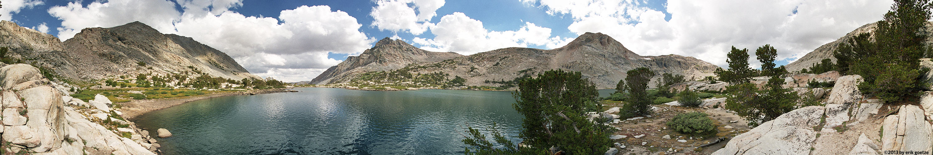 This 360 panorama is from Piute Lake, California
VirtualParks parks
USA > California > Mid Santa Cruz Mountains >
Virtual Ano Nuevo State Park - Cascade Ranch viewpoints | ||||
|---|---|---|---|---|
| [ No pano map available | Open the official park website in a new window ] | ||||
|
|
|
|
|
|
| Ano Nuevo State Park - Cascade Ranch | alongside Highway 1 |  | 715 KB | |
| Beyond Cascade North Knob |  | 592 KB | View looking into Whitehouse Creek valley | |
| Big Fir overlooking Whitehouse Creek |  | 1061 KB | Incredible old tree with nice view of wild portion of the creek. | |
| Boar forest 1 |  | 634 KB | An incredible steep forest, rarely seen by humans | |
| Boar forest 2 |  | 636 KB | Taken from the edge of the pocket forest | |
| Cascade North Knob |  | 595 KB | The trail was so overgrown, it was like crossing a jungle of poison oak. | |
| Cascade North Knob, 2nd time |  | 1061 KB | Incredible 180 view from Pigeon point to Ano Nuevo and beyond. | |
| Clearing on way to Cascade Knob |  | 580 KB | Through the trees, a nice view of Ano Nuevo Island | |
| Draw between Old Woman's Creek and White House Creek |  | 547 KB | It threatened to rain while capturing this spot | |
| East end of Meadow south of Whitehouse Creek |  | 761 KB | This is probably very near the site of the large Ohlone village. | |
| Fir Forest |  | 633 KB | Tree-shaded view of Ohlone Valley | |
| Grassy clearing |  | 1048 KB | Marine layer in process of moving in to Cascade Ranch | |
| Highway 1 and Whitehouse Road |  | 720 KB | ||
| Hill 535 |  | 587 KB | ||
| Hill 600 |  | 739 KB | Could almost see Pigeon Point lighthouse | |
| Hill next to Whitehouse Road |  | 671 KB | Low clouds stick to the mountaintops--sun was just coming out. | |
| Hill overlooking Whitehouse Creek |  | 663 KB | Survey flagging caused mis-focus | |
| Knocked down old house in Ohlone Valley |  | 1057 KB | Not a very stable platform, in fact probably pretty unsafe | |
| Lagoon near Whitehouse Road |  | 711 KB | ||
| Looking down into Ohlone Valley |  | 595 KB | Evening's light on the dried grass of the old ranch road leading down | |
| Meadow south of Whitehouse Creek |  | 715 KB | Incredible picturesque area | |
| Meadow to north of Whitehouse Creek |  | 855 KB | Beautiful view of surrounding forested mountains | |
| N-WHCK1 |  | 928 KB | ||
| N-WHCKMD (meadow) |  | 570 KB | ||
| Northern ridge road |  | 1049 KB | Could see Ano Nuevo from here | |
| NRIDGE1 |  | 778 KB | ||
| NRIDGE2 |  | 813 KB | ||
| Ohlone Meadow at sunset |  | 692 KB | ||
| Old fire road north of Old Woman's Creek |  | 888 KB | Scant trace of old road | |
| Old ranch road |  | 1057 KB | In person, you could see Big Sur on the southern horizon. | |
| Old road ascending to North Knob |  | 599 KB | Over the poison oak, view towards Butano | |
| Pampas Grass ridge |  | 1049 KB | Good view of hill which might be developed with a house | |
| Reservoir |  | 736 KB | The reservoir is quite muddy. Some unusual flowers on the trail to here. | |
| Ridge below girl scout camp |  | 649 KB | This road also becomes total thicket a short distance beyond here. | |
| Slope beyond west end of Meadow south of Whitehouse Crk |  | 853 KB | Nice view of entire meadow/valley | |
| U-shaped ravine north of Ohlone Valley |  | 627 KB | Trying to capture this interesting stand of trees above the ravine | |
| Under big Buckeye |  | 631 KB | Looks like the old trail goes down to the creek, maybe crosses it. | |
| Upper Reservoir nr 2 |  | 577 KB | Handheld pano | |
| West end of Meadow south of Whitehouse Crk |  | 762 KB | ||
| Whitehouse Creek redwood crossing |  | 634 KB | Someone built a fire and camped here recently | |
| Whitehouse Creek streambottom nr 1 |  | 1034 KB | A small redwood forest exists here along the stream | |
| Whitehouse Creek streambottom nr 6 | 679 KB | |||
| Whitehouse Road nr 1 |  | 665 KB | ||
| Whitehouse Road nr 2 |  | 653 KB | ||
| Whitehouse Road nr 3 |  | 674 KB | ||
| Whitehouse Road nr 4 |  | 723 KB | ||
| (46 scenes in this park) | ||||
For a different panorama every day, visit VRlog.com, which works in all popular browsers and supports fullscreen viewing and WebVR.