-
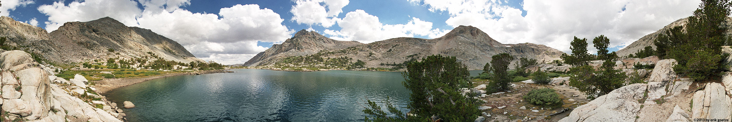 This 360 panorama is from Piute Lake, California
VirtualParks Ocean and Beaches
Ocean and Beaches
| General Area | Location | Size | |
| Ano Nuevo State Reserve | Ano Nuevo Pond | 575 KB | A bird watcher came into the scene while I was shooting it. |
| Ano Nuevo State Reserve | Ano Nuevo Beach and Preserve Boundary | 622 KB | Using tripod extender, was quite windy |
| Ano Nuevo State Reserve | near Cascade Creek and beach | 757 KB | |
| Ano Nuevo State Reserve | Cove south of Franklin Point | 606 KB | The only tree on Franklin Point is making a valiant stand against the wind. |
| Ano Nuevo State Reserve | Rocky point south of Franklin Point | 585 KB | Fog and clouds obscure most of the distant features. |
| Ano Nuevo State Reserve | Ano Nuevo middle beach | 1028 KB | Many tourists were here, it was cold and windy and I spent an hour or two here. |
| Ano Nuevo State Reserve | Ano Nuevo south beach | 1013 KB | Some seals can be seen climbing the beach |
| Baylands Nature Preserve | Observation Deck at Extreme High Tide nr7 | 628 KB | |
| Baylands Nature Preserve | Observation Deck at Extreme High Tide nr6 | 525 KB | |
| Baylands Nature Preserve | Byxbee Park Hills nr 4 | 451 KB | |
| Baylands Nature Preserve | Mayfield Slough lock | 877 KB | |
| Baylands Nature Preserve | Adobe Creek Trail near Hooks Island | 624 KB | |
| Baylands Nature Preserve | Adobe Creek Trail Charleston Slough | 654 KB | |
| Baylands Nature Preserve | Adobe Creek Trail at many forks | 659 KB | |
| Baylands Nature Preserve | Boardwalk Trail obs. deck | 801 KB | |
| Baylands Nature Preserve | Boardwalk Obs Deck Low Tide nr 4 | 557 KB | |
| Baylands Nature Preserve | Boardwalk Obs Deck High Tide nr 3 | 545 KB | |
| Baylands Nature Preserve | Boardwalk Obs Deck High Tide nr 5 | 561 KB | |
| Baylands Nature Preserve | On Sailing Station | 673 KB | |
| Baylands Nature Preserve | Above Sailing Station | 432 KB | |
| Baylands Nature Preserve | Boardwalk Trail Obs. Deck at high tide nr 4 | 920 KB | |
| Baylands Nature Preserve | Boardwalk Obs. Deck Low Tide nr 1 | 1045 KB | |
| Baylands Nature Preserve | Boardwalk Obs. Deck Low Tide nr 2 | 771 KB | |
| Big Basin Redwoods State Park | Waddell Beach | 653 KB | |
| Big Basin Redwoods State Park | Waddell Beach by Highway 1 Overpass | 608 KB | |
| Coastside Beaches | Beach near Franklin Point | 813 KB | |
| Coastside Beaches | Franklin Point | 953 KB | To the north, Pigeon Point is visible (with enough resolution), to the south, Ano Nuevo Island. |
| Coastside Beaches | Point Montara Lighthouse nr 3 | 659 KB | South of the Lighthouse |
| Coastside Beaches | Davenport cliff | 583 KB | ROLL3. A whale was breaching while I was taking these shots. |
| Coastside Beaches | Pillar Point nr 2 | 585 KB | This completes a loop of 300 panoramas, back at the site of my first. |
| Coastside Beaches | Gazos Creek/Beach | 617 KB | The edge of the stormfront created a night and day division. |
| Coastside Beaches | Greyhound Rock | 616 KB | View from on top of the rock; storm front approaching in the north. |
| Crescent City | Crescent City Lighthouse | 524 KB | Lots of tourists from Europe here |
| Capitola | West Bluffs overlooking Capitola | 880 KB | |
| Capitola | Capitola Beach | 1111 KB | |
| Capitola | Capitola Pier | 986 KB | Shot with a home-made panhead |
| Golden Gate National Recreation Area | Point Bonita Lighthouse nr 3 | 304 KB | From the back, only with a wider angle lens |
| Golden Gate National Recreation Area | Point Bonita Lighthouse nr 2 | 631 KB | From the "back" of the lighthouse, facing the great Pacific |
| Golden Gate National Recreation Area | Point Bonita Lighthouse nr 1 | 544 KB | The "front" of the lighthouse, with interpretive panel. |
| Montara | Pillar point harbor, at base of hill | 814 KB | No remote shutter release; didn't adjust for focal point of tamron lens; rig was not quite level |
| Point Lobos State Reserve | Point Lobos sunset | 402 KB | |
| King Range National Conservation Area | Punta Gorda Lighthouse | 459 KB | The BLM tore down supporting structures in 1970. |
| Montana de Oro | Sand spit north end nr2 | 953 KB | Looking at a huge beached bouy |
| Montana de Oro | Sand spit north end nr3 | 852 KB | Over the dunes, a great view of Morro Bay and Morro Rock |
| Montana de Oro | Sand spit north end nr1 | 655 KB | |
| Montana de Oro | Dune Trail view of Spooner's Cove | 492 KB | It was not clear whether the sun would come out or not, but it eventually did. |
| Montana de Oro | Dune Trail dune | 563 KB | Near here on a dune top I fell into an animal hunting trap! |
| Montana de Oro | South lip of Hazard Canyon | 582 KB | There was someone with a hang-glider on the north rim |
| Andrew Molera State Park | Bluff at mouth of Big Sur River | 580 KB | The beach below has many well-built driftwood enclaves for shelter from the wind |
| Andrew Molera State Park | Bluff Trail near river outlet | 576 KB | Trail |
| Andrew Molera State Park | Spring Trail/Beach | 597 KB | Incredible collection of drift-logs piled up here. Quite windy on this day. |
| Andrew Molera State Park | Chair and Table at South Edge of park | 562 KB | This comfy spot just above where the Ridge Trail turns onto the Panorama Trail. |
| Andrew Molera State Park | Molera Ridge Overlook | 590 KB | Ultra windy, haze obscured Point Sur lighthouse point |
| Natural Bridges State Beach | Natural Bridges beach | 387 KB | SCZBC8 |
| Los Padres National Forest (Northern) | Partington Ridge overlook, from below logpile | 963 KB | |
| Los Padres National Forest (Northern) | Coast Ridge above Partington Ridge nr5 | 890 KB | |
| Los Padres National Forest (Northern) | Coast Ridge above Partington Ridge nr1 | 816 KB | Great views deep into Ventana Wilderness and of the Pacific Ocean |
| Los Padres National Forest (Northern) | Viewpoint just below Coast Ridge | 769 KB | After a long stretch under tree canopy, the view is unbelievable |
| Los Padres National Forest (Northern) | Poppies on Partington Ridge nr2 | 837 KB | The broom plant, while pretty, is non-native |
| Los Padres National Forest (Northern) | Poppies on Partington Ridge nr1 | 1008 KB | Perhaps the best poppy field with a view I've seen |
| Los Padres National Forest (Northern) | Old DeAngulo Trail viewpoint nr2 | 563 KB | The trail does not exist here anymore; but the views are stunning |
| Los Padres National Forest (Northern) | Old DeAngulo Trail viewpoint nr1 | 533 KB | Could see and hear sea otters in the turquoise colored coastal waters |
| Los Padres National Forest (Northern) | Old DeAngulo Trail 250 yards from TH | 772 KB | Had to push through a thicket of poison oak to get here |
| Pigeon Point Light Station State Historic Park | South of Pigeon Point | 559 KB | In the fading sun, some interesting rock formations |
| Pigeon Point Light Station State Historic Park | On tidal flats south of Pigeon Point | 1104 KB | |
| Pigeon Point Light Station State Historic Park | On rocks next to Pigeon Point | 1063 KB | |
| Pigeon Point Light Station State Historic Park | Small bluff over beach next to Pigeon Point | 950 KB | |
| Pigeon Point Light Station State Historic Park | Rocky point over beach next to Pigeon Point | 974 KB | |
| Pigeon Point Light Station State Historic Park | Bluffs overlooking beach south of Pigeon Point | 676 KB | Shot with a home-made panhead |
| Pomponio State Beach | Pomponio Beach Bluff | 595 KB | Excellent viewpoint of some fine coastside beaches |
| Pescadero State Beach | Pescadero Beach dune | 370 KB | The fogbank was trying to overrun the beach. |
| Pescadero State Beach | Pescadero Marsh overlook and bench | 584 KB | Pescadero Marsh is not only beautiful to look at, but a vital habitat |
| Pescadero State Beach | Pescadero Marsh | 473 KB | Late in the day, but the sun is still pretty high. |
| Point Reyes National Seashore | Hilltop view along trail to Chimney Rock | 646 KB | |
| Point Reyes National Seashore | Chimney Rock overlook nr4 | 452 KB | |
| Point Reyes National Seashore | Above Pt. Reyes Lighthouse nr 1 | 504 KB | The foghorn was blaring the whole afternoon |
| Point Reyes National Seashore | Kehoe Beach bluff nr 1 | 978 KB | |
| Point Reyes National Seashore | Kehoe Beach bluff nr 2 | 986 KB | |
| Point Reyes National Seashore | Kehoe Beach bluff nr 3 | 989 KB | |
| Point Reyes National Seashore | Kehoe Beach bluff nr 4 | 1036 KB | |
| Point Reyes National Seashore | Kehoe Beach bluff nr 5 | 961 KB | |
| Point Reyes National Seashore | Kehoe Beach bluff nr 6 | 970 KB | |
| Point Reyes National Seashore | Kehoe Beach bluff nr 8 | 893 KB | |
| Point Reyes National Seashore | Kehoe Beach bluff nr 10 | 609 KB | |
| Point Reyes National Seashore | Above Pt. Reyes Lighthouse nr 2 | 483 KB | Taken from the same spot as nr2, but higher up |
| Point Reyes National Seashore | Pt. Reyes Lighthouse | 459 KB | Pt. Reyes is reputed to be the second foggiest place in the US. |
| Point Reyes National Seashore | Below Chimney Rock viewpoint | 553 KB | |
| Point Reyes National Seashore | Point Tomales Trail nr3 | 650 KB | |
| Point Reyes National Seashore | Tomales Point Trail nr4 | 662 KB | A herd of Tule Elk were grazing in the valley below |
| Point Reyes National Seashore | At Chimney Rock overlook nr1 | 520 KB | |
| Point Reyes National Seashore | At Chimney Rock overlook nr2 | 636 KB | |
| Point Reyes National Seashore | Viewpoint midway on trail to Chimney Rock | 531 KB | It was incredibly windy here, hard to shoot with big gusts |
| Point Reyes National Seashore | Clifftop view from midway to Chimney Rock | 679 KB | |
| Point Reyes National Seashore | McClure Beach south end, near Elephant Rock | 725 KB | |
| Point Reyes National Seashore | McClure Beach near Elephant Rock | 695 KB | |
| Point Reyes National Seashore | McClure Beach | 408 KB | |
| Point Reyes National Seashore | Entrance to McClure Beach | 867 KB | |
| Point Reyes National Seashore | Hilltop overlooking peninsula nr3 | 824 KB | Could see Tamales Point as well as Point Reyes |
| Point Reyes National Seashore | Hilltop overlooking peninsula nr1 | 743 KB | |
| Point Reyes National Seashore | Closeup of flowers along trail to Chimney Rock | 637 KB | |
| Santa Cruz | Boat exhibit on Wharf | 358 KB | |
| Santa Cruz | Beach next to the Wharf | 370 KB | |
| Santa Cruz | Next to the Wharf | 766 KB | |
| Santa Cruz | Santa Cruz Boardwalk/Beach | 289 KB | SCZBC1 |
| Santa Cruz | Santa Cruz Boardwalk/Beach nr 5 | 284 KB | SCZBC5 at the north end of the carnival ride area? |
| Santa Cruz | Lighthouse Point | 481 KB | |
| Santa Cruz | Santa Cruz Yacht Harbor outlet | 492 KB | |
| Santa Cruz | Santa Cruz Boardwalk/Beach nr 4 | 272 KB | inside the carnival ride area |
| Santa Cruz | Santa Cruz surfer statue 'To Honor Surfing' nr 1 | 334 KB | A great day. Sunny, clear, not too cold after the storm. |
| Santa Cruz | Santa Cruz small craft harbor nr 1 | 541 KB | SCZBC9 |
| Santa Cruz | Santa Cruz small craft harbor nr 2 | 519 KB | SCZBC0 |
| Santa Cruz | Santa Cruz Boardwalk/Beach nr 3 | 426 KB | SCZBC3 |
| Santa Cruz | Next to Santa Cruz Lighthouse | 353 KB | Storm clouds to the north were spectacular |
| Big Sur | Tin House nr 2 | 424 KB | |
| Big Sur | Rocky Creek Bridge | 587 KB | First regular pano using KiWi panhead |
| Big Sur | Big Sur coast nr 2 | 591 KB | |
| Big Sur | Tin House nr 1 | 326 KB | This house is made of tin by an admiral or captain around the days of WWII. |
| Big Sur | Point Sur Lighthouse nr 2 | 607 KB | The lighthouse uses similar rock facing as old buildings at Stanford. |
| Big Sur | Point Sur Lighthouse Keeper's Dwellings | 749 KB | |
| Big Sur | Point Sur Lighthouse Blacksmith Shop | 495 KB | This was shot down below the new water tank |
| Big Sur | Point Sur Barracks Visitor Center | 496 KB | A superb view looking back on the "mainland" |
| Big Sur | Big Sur coast nr 3 | 573 KB | It was more beauitful than film can record |
| Wilder Ranch State Park | Old Cove Landing Trail near Overlook nr2 | 737 KB | |
| Wilder Ranch State Park | Old Cove Landing Trail past Overlook | 715 KB | |
| Wilder Ranch State Park | Old Cove Landing Trail Overlook nr2 | 697 KB | |
| Wilder Ranch State Park | Bluff over 4 Mile Beach nr 3 | 690 KB | |
| Wilder Ranch State Park | Fern grotto | 934 KB | |
| Wilder Ranch State Park | Bluff over 4 Mile Beach nr 1 | 682 KB | |
| Wilder Ranch State Park | Bluff over 4 Mile Beach nr 2 | 798 KB | |
| Wilder Ranch State Park | Coast cliffs overlooking sea lion spot | 910 KB | |
| Wilder Ranch State Park | Coast viewpoint | 833 KB |
For a different panorama every day, visit VRlog.com, which works in all popular browsers and supports fullscreen viewing and WebVR.